Pleasant 48 Hours In DFW Before Frozen Precipitation, Arctic Front Arrives Friday
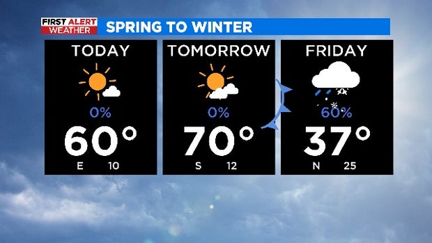
NORTH TEXAS (CBSDFW.COM) - Weather across North Texas will be pleasant for the next 48 hours. While mornings will be chilly, afternoons will be mild and high temperatures will be closer to average -- in the 60s and 70s. Expect plenty of sunshine, blue skies and dry conditions.
But — there's always a but — all eyes are on the Friday forecast! CBS 11 Meteorologist Anne Elise Parks said she "feeling cautiously optimistic" after seeing the latest weather models. As it stands, the winter weather moving in toward the weekend doesn't appear to be a repeat of past North Texas winter events this year.
Parks said, "On the scale of intensity/impact, this is setting up to be on the lower side."
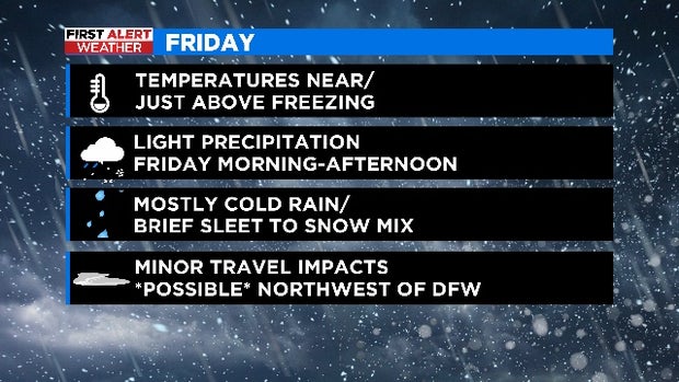
Temperatures on Friday don't appear to be as cold [as past systems] and the window of precipitation is small. On top of that, there doesn't look to be a lot of moisture moving in. There could be some areas (especially to the south) that don't see any precipitation.
Some light, scattered precipitation still appears possible from Friday morning into the afternoon, with the highest chances of a winter mix (sleet/snow) being northwest of DFW. But that doesn't mean the Metroplex won't see some sleet pellets or snowflakes flying around. The good news is the frozen precipitation likely won't be heavy enough or cold enough to have any significant accumulation.