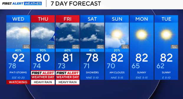
Threat of heavy rain, hail and flooding returns to North Texas this week


A significant pattern change begins Wednesday as a strong upper-level disturbance approaches from the west, and a Pacific front moves into Texas. Deep tropical and Gulf moisture will already be in place.
Showers and thunderstorms will initially develop near the front across western portions of the region Wednesday afternoon. The bigger concern develops Wednesday night as thunderstorms become widespread along a nearly stationary frontal boundary.
Storms will move nearly parallel to the boundary, creating the potential for training thunderstorms, where repeated rounds of heavy rain move across the same locations.
A flood watch is in effect for much of North Texas Wednesday afternoon through Friday morning. The primary concern remains repeated rounds of heavy rain and the potential for flash flooding Wednesday night into Thursday. There is also a low severe-weather threat Wednesday afternoon and evening, primarily along and west of US-281. A couple of storms could become strong to severe with large hail and damaging winds.
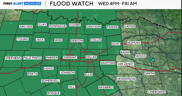
Tuesday is one final hot and dry afternoon with highs in the lower to middle 90s. Southerly winds remain gusty at 15–25 mph as the pressure gradient tightens ahead of the approaching system. High clouds will continue increasing, but rain is not expected.
Tuesday night, quiet and warm conditions continue as deeper moisture increases ahead of the approaching upper-level system. Most of North Texas remains dry overnight.
Storm timing for North Texas
Wednesday morning
The morning should start relatively quietly for most of the metroplex. Rain will begin developing first across western North Texas, but widespread heavy rain is not expected during the first half of the day.
Wednesday afternoon/evening: coverage ramps up
Scattered showers and thunderstorms develop near the frontal zone, initially favoring western North Texas. A couple of storms along and west of US-281 could become strong to severe during the afternoon and evening.
The primary hazards will be large hail and damaging winds. Rain and thunderstorm coverage will continue increasing on Wednesday evening.
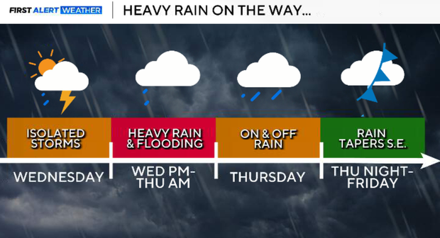
Wednesday night - flood threat increases
Widespread thunderstorms are expected to develop along a nearly stationary frontal boundary. Because storms will move nearly parallel to this boundary, repeated rounds of heavy rain could move across the same locations.
The greatest flash-flood threat Wednesday night initially favors areas along and west of US-281.
Thursday: flood threat shifts east
During Thursday, the axis of greatest flooding concern should gradually shift east toward the I-35 corridor as training showers and thunderstorms continue moving east. Some locations experiencing persistent rain may remain in the 70s Thursday afternoon, while highs generally remain in the 80s elsewhere.
Thursday night
The main upper-level disturbance begins lifting northeast. Showers and thunderstorms become more scattered, and the overall flooding threat should gradually decrease Thursday night, although isolated flooding will remain possible.
Friday
The flood watch currently extends through Friday morning. Scattered showers and thunderstorms remain possible as weak troughing and a lingering frontal boundary remain nearby, but the latest guidance no longer depicts Friday as a distinct second heavy-rain round. Temperatures remain considerably lower than earlier this week.
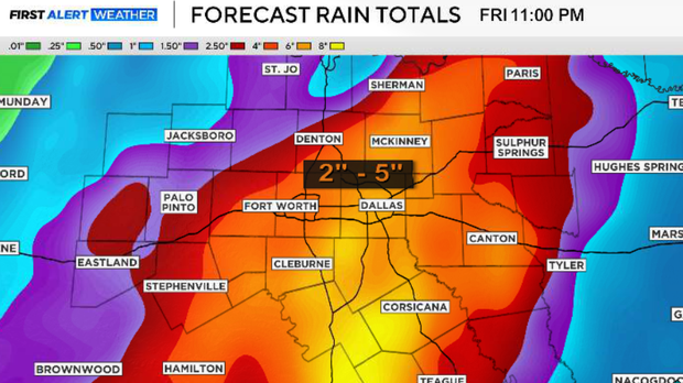
Rainfall/flooding:
Widespread storm totals of 2–5 inches are expected, with localized amounts up to 6 inches possible where training thunderstorms develop. The primary concern with this event is flash flooding rather than widespread severe weather.
This weekend
Scattered showers and non-severe thunderstorms remain possible Saturday and Sunday as a weak boundary lingers across the region. Rain chances should gradually decrease Sunday as a more substantial cold front moves south through North Texas. Highs this weekend should generally remain in the upper 70s to lower 80s.
Early next week
A much more fall-like air mass settles into North Texas. Highs remain mainly in the 70s and 80s, while overnight lows fall into the upper 50s and lower 60s. Drier air also arrives, with dew points eventually falling into the 50s.