Update: Storm system slams into Bay Area unleashing deadly wind gusts
SAN FRANCISCO -- A pair of spinning low-pressure systems rotating around a common center, parked off the California coast, was adding another layer of misery for rain-weary Bay Area residents.
The howling winds toppled a large tree Tuesday afternoon onto a vehicle at Alpine and La Cuesta near Menlo Park, claiming the life of the driver.
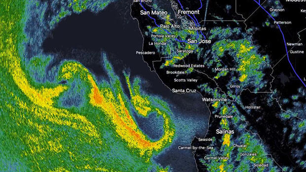
In a season of weather oddities, a new phrase was added to local vocabulary Tuesday afternoon. It's called the "Fujiwhara Effect" and is the interaction between two similarly sized low-pressure centers rotating around a common center.
The combination, forecasters said, will whip up 60 mph winds and leave toppled trees and downed powerlines in the storm's wake.
KPIX 5 First Alert Weather: Current Conditions, Forecasts, Alerts For Your Area
By 1:30 p.m., the first of the low-pressure systems was beginning to come onshore in Santa Cruz County. The National Weather Service issued a severe thunderstorm warning including Santa Cruz, Scotts Valley and Capitola as conditions were beginning to deteriorate.
Wind gusts reached 76 mph in Santa Cruz mountain communities, including Boulder Creek.
Resident Frank Kuhr waited for hours Tuesday afternoon at a downtown supermarket for crews to remove large redwoods that were blocking a highway. "Trees are down everywhere," Kuhr said. "The wind has been unbelievable. Branches were flying through the air, and folks could hear trees just falling and cracking."
"This one's a doozy," Kuhr said.
Highway 17 was closed in both directions by a fallen tree that also downed wires at around 1:15 p.m., but the highway reopened about an hour later.
However, there were numerous other road closures reported throughout Santa Cruz County due to downed trees and flooding.
Other high winds reported included gusts of 78 mph at Mount Umunhum in Santa Clara County and Los Gatos and a 74 mph gust recorded at the Oakland Airport. All three Bay Area airports were reporting delays and cancellations due to the storm, with San Francisco International seeing the most significant impacts.
KPIX reporter Lauren Toms shared photos from her parents showing a large tree that fell in their Redwood City neighborhood.
Meanwhile, the damaging gusts triggered power outages in Santa Clara where utility officials tweeted -- "We currently have multiple small outages throughout the city due to high winds. Our field crews are responding. No additional information is available at this time."
The winds were also whipping up waves on the Bay. The San Francisco Bay Ferry canceled several trips due to strong winds and rough waters during Tuesday's storm. SF Muni's F Market streetcar was switching back from inbound to outbound at Ferry Plaza due to flooding since Tuesday morning. Bus shuttles wre being provided to cover the portion of the streetcar's route along the Embarcadero.
KPIX Anchor Sara Donchey posted video that showed how intense the waves were near the Embarcadero Tuesday afternoon.
Depending on where you live, the showers could also be pretty intense.
"The accompanying rain looks to be heavy at times, especially over the Santa Lucia Mountains and Santa Cruz Mountains where maximum rainfall totals by Wednesday are forecast to get up to around 6-7 inches and 4-5 inches, respectively," the weather service said.
The Santa Cruz office of the CHP announced that Highway 17 through the Santa Cruz Mountains was closed early Tuesday afternoon at around 1:20 p.m. Caltrans confirmed that there was a tree and wires down just south of Mt. Hermon.
State Route 9 near Bear Creek Road was also closed in both directions with a tree down and powerlines across all lanes.
"Corresponding lower elevation rainfall totals look to be in the 0.5-1.0 inches range in the North Bay, 0.75-1.25 inches heart of the San Francisco Bay Area, and 1.0-2.0 inches in the Monterey Bay region."
An urban and small creek warning was issued Tuesday morning by the weather service for the South Bay as heavy rain fell across the region.
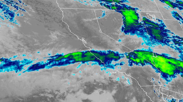
While the weather conditions created treacherous driving conditions during the morning commute, the storm's fury was largely targeting the waterlogged Monterey Peninsula and communities south to Los Angeles with a Cat. 3 atmospheric river.
The river will dump as much as 6 inches in the foothills and mountains of the Central Coast and Southern California by Wednesday night.
"Rainfall rates will generally range between 0.25-0.50 inches/hour, but local rates of 0.50-1.00 inches/hour will be possible with the front and associated with any thunderstorm activity," the National Weather Service warned.
A flood watch is in effect for the area due to the very wet conditions and expected rainfall. In the Bay Area -- which has just recovered from a fierce windstorm that left 300,000 without power -- once again was facing the threat of damaging gusts.
A high wind warning went into effect at 7 a.m. and will linger for the rest of the day along the coast. A high wind advisory was in place for the inland communities. The gusts of up to 60 mph will be enough to down power lines, rip off branches and topple trees.
"It appears two bands of especially strong winds, extending out like the arms of a pinwheel, will rapidly move through from off the Big Sur coast," the weather service said. "The first Tuesday morning and the second Tuesday afternoon. Highest wind speeds in both cases look to be focused over the southern half of our district, with highest gusts in windiest locations potentially reaching up into the 65-75 mph range."
Forecasters warned Bay Area residents of the dangers the winds with the saturated soils and weakened trees present.
"People should avoid being outside in forested areas and around trees and branches," forecasters said. "If possible, remain in the lower levels of your home during the windstorm, and avoid windows."
Forecasters also warned that with the projected accompanying strong lower tropospheric vertical wind shear, you "can't rule out the possibility of a waterspout, or local spinup over land, and will need to carefully monitor the radar. Small hail could also occur."


