Update: 'Storm door blows wide open;' Flood Watch issued for Bay Area
SAN FRANCISCO -- The advice from the National Weather Service forecasters when it comes to a subtropical storm front that arrives Thursday -- "buckle up, it's going to be quite the weather ride."
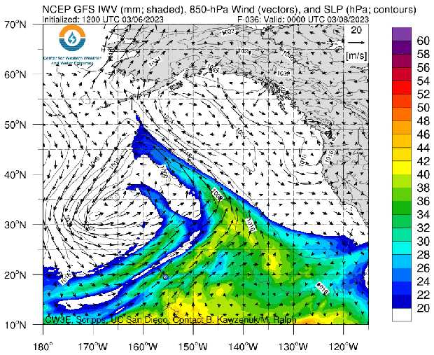
The jet stream that will slam the system into California will carry with it an atmospheric river. Forecasters at the Center of Western Weather and Water Extremes say it will rank as a 4 on a scale of 5 in intensity. That's quite a gut punch for a region that has seen a steady parade of rain showers since Dec. 26.
UPDATE: Atmospheric river gaining strength as it nears Northern California
The growing predicted intensity of the storm triggered the weather service to issued a flood watch for the entire Bay Area beginning on Thursday and stretching to Sunday morning.
KPIX 5 First Alert Weather: Current Conditions, Forecasts, Alerts For Your Area
"The storm door blows wide open on Thursday as the North Pacific ridge breaks down and allows a strong upper-level jet to transport subtropical moisture to our region," the weather service said. "Our first atmospheric river storm will arrive Thursday afternoon and bring wind, rain, and snow impacts through the weekend."
For a region that has suffered through a near-historic drought for much of the previous five years, a forecast of significant rain would be greeted with joy.
But now it's become a matter of how much is too much. The soil has become saturated and unstable. Trees have toppled with fatal consequences -- 44-year-old Vidyut Nautiyal of San Jose was fatally struck by a tree while on a hike with her Boy Scout son over the weekend.
In the Sierra, more than 50 feet of snow has fallen since the beginning of the season. Residents are trapped in their snowbound homes and each day brings a growing concern of deadly avalanches.
"Expect up to 2 feet of new snow accumulation on the Sierra crest generally north of US-50, 4-8 inches in the Tahoe Basin (on Tuesday-Wednesday)," said Reno NWS forecasters of the bands of wintry weather moving through before the big storm hits.
The subtropical moisture of the Thursday-Saturday storm will bring a new threat with it. Snow levels will be at 8,000 feet; below that, warm rain will fall triggering a quick snow melt.
"Heavy rainfall coupled with this mild air mass will result in rapid snow melt from 2,000 feet to 5,000 feet," forecasters warned. "Water levels on rivers and streams will rise and flooding is possible."
Here is a timeline and projected rain totals in the Bay Area for Thursday and Friday:
Thursday:
- North Bay: 0.75"-2" (highest in the coastal mountains)
- SF Peninsula: 0.75"-1" (highest in the coastal terrain)
- East Bay: 0.5"-1" (highest closer to the Bay Shoreline)
- South Bay: 0.5"-1.25" (highest in Santa Cruz Mtns)
- Santa Cruz: 0.9"-1.6" (highest in Santa Cruz Mtns)
- Monterey & San Benito Counties: 0.20"-1.75" (highest along Big Sur Mtns, lowest across southeastern portions of each county)
Friday:
- North Bay: 1.25"-3" (highest in the coastal mountains)
- SF Peninsula: 1.25"-3.25" (highest in the coastal terrain)
- East Bay: 0.8"-2.25" (highest in terrain closer to Bay Shoreline)
- South Bay: 1"-3.5" (highest in Santa Cruz Mtns)
- Santa Cruz: 2"-4.25" (highest in Santa Cruz Mtns)
- Monterey & San Benito Counties: 0.50"-6" (highest along Big Sur Mtns, lowest across southeastern portions of each county)
"Showers continue over the weekend, but won't be as heavy," the weather service said. "For Saturday and Sunday combined another 0.5-1" could fall across North Bay while the rest of the Bay Area should get 0.25-1", Santa Cruz with an additional 0.75-1.25"
Meanwhile, Monterey County officials have warned residents in the Big Sur area to prepare to be isolated for up to two weeks.
The issue is the landslide-prone stretch of Highway 1 along the coast.
Officials with Monterey County's Department of Emergency Management issued the alert late Monday after the weather service forecast another atmospheric river that could be stronger than recent storms that caused major damage throughout the county and elsewhere in Northern California.
Storms in January and February caused landslides north of Big Sur that forced a three-week closure of state Highway 1, isolating residents. Authorities airlifted supplies to residents in the interim.
The forecast this week calls for high water levels in the Big Sur River and other Monterey County rivers, and the potential for record-low temperatures and record rainfall totals.