Atmospheric river gaining strength as it takes aim at Northern California
SAN FRANCISCO -- Like a truly unwanted guest, an intensifying sub-tropical atmospheric river was now expected to arrive early, crashing into Northern California on Thursday afternoon.
The strength of the incoming storm front made Wednesday's showers seem like just a minor annoyance for the morning rush hour.
KPIX 5 First Alert Weather: Current Conditions, Forecasts, Alerts For Your Area
"The atmospheric river looks like it will be knocking on the coastline with an earlier arrival," the National Weather Service said. "Yesterday, the moisture plume showed an arrival Thursday in the late afternoon/evening hours, but latest guidance shows that it could start hitting the Central CA and NorCal coast Thursday morning to early afternoon."
Officials warn local residents that once those showers move on they had about 24 hours to prepare for a much more powerful blast, especially for the communities nestled in the Santa Cruz Mountains.
ALSO READ: Storm prep: Where to get sandbags in the Bay Area
"While all coastal mountain regions will see higher rain totals, the focus remains across the Santa Cruz and Santa Lucia Mountains of the Big Sur coast," the National Weather said. "For Santa Cruz Mountains, peak rain totals Thursday through Friday had ranged 4.5-6.3 inches but have now increased to a range of 5-7.5 inches."
"This would be a good time to finish any outdoor prep you might need to do ahead of the incoming atmospheric river that arrives Thursday," forecasters continued.
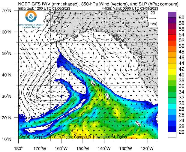
Early in the week, the atmospheric river was a Cat. 3 out of a scale of 5. By Wednesday, the potent plume of moisture had been upgraded to a Cat. 4.
The weather service has issued a Bay Area-wide Wind Advisory for Thursday 1 p.m. through Friday at 4 p.m. as we expect gusts up to 50 mph.
The combination of wind, saturated soil and weakened trees could be life-threatening across the region.
"Similar to the storms we experienced in January -- soils are fairly saturated already so the combination of heavy rain with gusty winds means it will be easier for downed trees and power outages," forecasters warned.
Unlike the storms of the last 2 weeks, this plume of subtropical moisture will raise the snow levels in the Sierra to above 8,000 feet.
"This means rain will fall on snow from 2000ft to 5000ft, causing flooding concerns as the snow melts," the weather service said.
A flood watch has been issued for a region that includes the Bay Area, Sacramento and the Central Coast from Thursday afternoon through Sunday morning. Runoff will also impact the Delta east of the San Francisco Bay Area.
Meanwhile, officials in Monterey County, just south of San Francisco, have made sandbags available to residents who live near waterways at risk of flooding. The county's emergency officials have also urged people in the Big Sur area to have at least two weeks worth of "essential supplies" in preparation for this week's atmospheric river and winter storm.