Temperatures begin to warm up as the weekend approaches in Pittsburgh, with wet weather expected
Skies began the process of clearing across the tri-state region overnight into this morning as high pressure and drier air nudge closer to the region. Where skies are clearing out, temperatures will easily fall into the mid-upper teens this morning with areas of frost.
We will continue to monitor areas of refreeze from melted snow.
WEATHER LINKS:
Current Conditions | School Closings & Delays | Submit Your Weather Photos
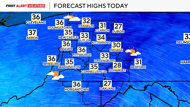
This afternoon, expect temperatures to reach the mid to upper 30s, which is closer to normal for this time of year. While most areas will see plentiful sun, some lingering clouds are likely north of HWY 422 to I-80.
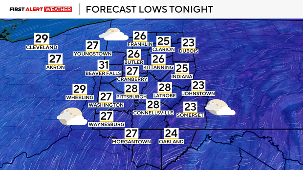
Overnight into Saturday, temperatures will briefly drop into the upper 20s to near 30 with waves of clouds.
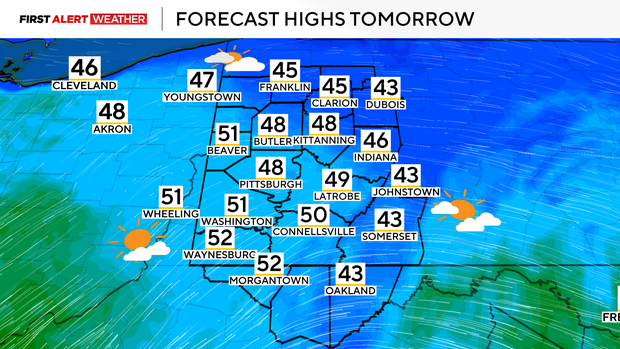
These waves of clouds will continue to pivot through on Saturday, but a westerly breeze will continue to allow mild air to move in with highs reaching the upper 40s to low 50s for most locations.
The system we are continuing to watch on Sunday continues to mainly favor a southerly track with the latest model guidance and model ensembles. For areas south of I-70, some light rain showers possibly mixed with snow are possible from midday through early evening Sunday.
After Sunday, a broad ridge of high pressure will develop in response to warmer air making a surge into the region. By next Tuesday, mid-50s are likely to return, with upper-50s possible by next Wednesday. Several disturbances will round the periphery of a ridge of high pressure starting Tuesday night into Wednesday.
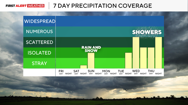
With increasing moisture levels, this will lead to periods of rain at various times starting Wednesday and likely continuing through the end of the week. At the moment, this does not look like a setup to generate heavy rain or flooding.

Stay up to date with the KDKA Mobile App – which you can download here!