Major snow storm will hit western Pennsylvania this weekend. Here's the forecast timeline.
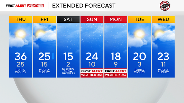
A major snowstorm is heading toward western Pennsylvania this weekend, set to arrive in the Pittsburgh area on Saturday evening with snow continuing through the day on Sunday. Snow showers will wrap up on Monday morning.
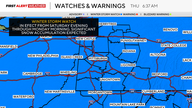
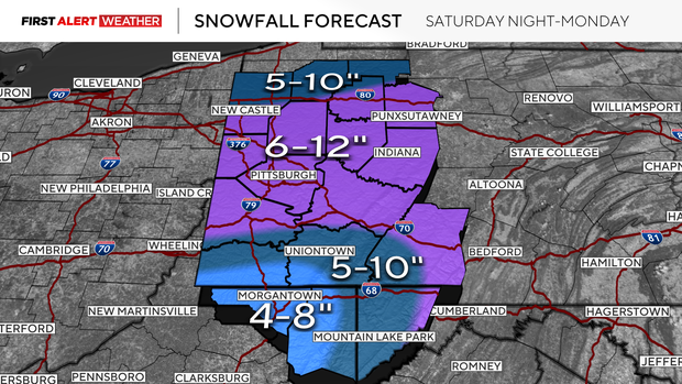
While you were sleeping, the National Weather Service issued winter storm watches for the entire area, indicating they expect at least six inches of snow. I think snow totals for our area will start at eight inches and only go up from there. There is a very real chance we will see a community or two seeing more than 16 inches of snow!
Places south of I-70 will have the highest chance to see spots with more than a foot of snow falling.
Snow storm timeline and totals in Pittsburgh area
Let's start by talking about timing.
Snow will begin around 10 p.m. on Saturday. Snow will come to an end around 2 a.m. on Monday. I have snow accumulations of around 3 - 5 inches by noon on Sunday. An additional 4 - 5 inches of snow may fall from Sunday at noon through around 10 p.m. on Sunday. At this point, it looks like the best-case scenario is that Pittsburgh only sees around 6 inches of snow.
It is almost certain that we will see more than 8 inches. The worst case scenario is for widespread average snowfall of near 12 inches of snow.
The progressive low-pressure system has not come together just yet and is expected to form on Friday near Oklahoma, New Mexico, and Texas. The powerful system will then track to the east. The path right now brings a swath of snow nearly 400 miles wide across the southwest, eventually impacting the Southeast states along with Maryland, Virginia, West Virginia, Delaware, & even here in Pennsylvania.
This is a major system that will cause numerous airport delays and traffic to come to a standstill in many cases. When traffic is moving, slick spots will be an issue, and a spike in energy bills and likely fires as people try to stay warm should be expected.
Why this storm is unusual
This storm is unusual in that, normally, the type of system that brings us big snow chances comes in from the southwest with a low-pressure track that takes it almost due north. This is the track that systems like 'snowmageddon' took. This system's movement is almost due east. I've often talked about how just because we can show evidence of human-induced global warming, it doesn't mean that we won't get big snowstorms anymore.
In fact, the opposite is true. This storm is probably the biggest proof of that theory I have seen. A storm that shouldn't exist at the levels it is expected to be, but somehow is going to roll through.
Stay up to date with the KDKA Mobile App – which you can download here!
WEATHER LINKS:
Current Conditions | School Closings & Delays | Submit Your Weather Photos