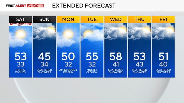
Pittsburgh temperatures reach into the 50s on Saturday, rain chances return Sunday
Satellite and radar imagery clearly show our next weather system that will impact our area on Sunday, working its way through Kansas, Missouri, Oklahoma, & Arkansas on morning scans. This baroclinic leaf is a deepening area of low pressure that will bring back-to-back severe weather days to parts of the Gulf Coast and southeast states. We will be on the 'stable' side of things with no severe weather being possible here as the center of the low passes to our south.
WEATHER LINKS:
Current Conditions | School Closings & Delays | Submit Your Weather Photos
This means wrap-around precipitation that brings light rain showers our way. Anytime you are on the northern edge of these types of systems, you can also get light snow as the warm air interacts and is lifted over a colder air mass in place.
For us, the chance for snow will start in the Ridges of Fayette and Westmoreland counties and extend to the east. If traveling on Sunday, expect light rain to change over to a mix of snow and rain around sunset, which occurs right at 6 p.m. Temperatures will be near 32 degrees for overnight lows, so the impact to drivers should be minimal, but I still want to give you a heads up with what is on the way.
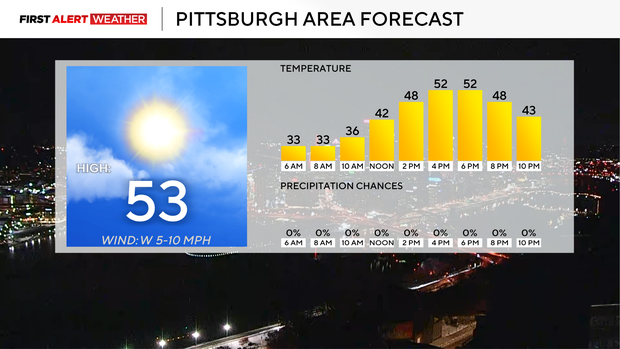
While we wait for rain, I have temperatures soaring to the 50s today with sunny skies to start the day. We will see thickening clouds as we head through the afternoon, with cloudy skies expected overnight. I have noon temperatures in the low 40s with 4 p.m. temperatures in the low 50s. Winds will be out of the southwest at around 10 mph. Sunset is at 5:55 p.m.
Looking ahead, rain chances on Sunday will be part of the reason why I only have highs in the 40s on Sunday.
I have Pittsburgh's high at 45°. Sunday is the only day of the 7-day period that I have not hit the 50° mark. I have Monday's high at 50 degrees. I have Tuesday's high hitting 55°.
Both days are looking dry.
Rain chances return later on Wednesday, but won't arrive early enough to keep temperatures out of the 50s. We may hit the 60° mark on Wednesday! I will keep us at 58° for the daily high. I have two chances for rain late in the week, with one system sliding through on Wednesday through Thursday and a secondary system sliding by on Friday.
Stay up to date with the KDKA Mobile App – which you can download here!