Severe weather brings tornado risk to Pittsburgh area on Thursday morning

Severe weather, including the potential for a tornado, is possible in the early morning hours of Thursday for parts of the Pittsburgh area, followed by strong winds for most of the day.
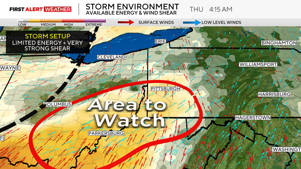
With this system passing through during the overnight and early morning hours, that is going to prevent a high-end severe weather outbreak from occurring. However, strong low level wind shear and strong winds aloft will still allow storms to be somewhat organized and carry a severe risk in the form of damaging winds along with an isolated tornado potential.
Where will storms hit?
The area we are most watching will generally be across southwest Pennsylvania from roughly Allegheny, Washington and Westmoreland counties and points south into northern West Virginia and west into eastern Ohio, as this is where available energy and moisture values will be the highest. The timing is between 2 a.m. and 9 a.m.
Strong winds to follow
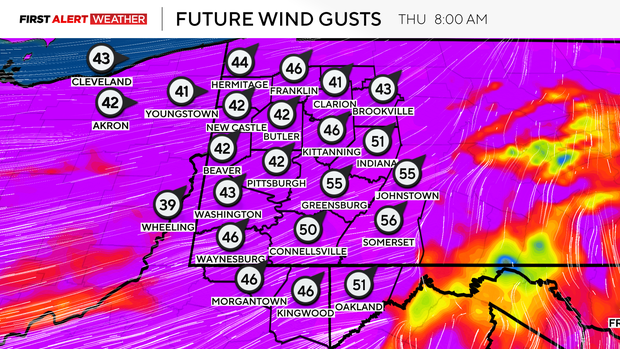
After storms exit the Laurel Highlands by 9 a.m. to 10 a.m. on Thursday, attention will turn to a strong gradient wind that will plow in behind the departing thunderstorm line. Deep atmospheric mixing of wind energy aloft and a tight pressure gradient will result in strong sustained winds between 20 mph to 30 mph. Gusts could exceed 55 mph in spots, especially in the peaks of the Laurel Highlands and ridges with the higher terrain deeper into the low level jet. Damage to trees and power lines and isolated power outages are possible.
The gradient winds will diminish after 4 p.m. to 5 p.m. Thursday, and a dry and comfortable air mass will build in behind this departing weather system.
Next chance of showers returns by Sunday evening
Several weak disturbances will traverse the Upper Ohio Valley, leading to partly cloudy skies, but with deep moisture scoured out, rain chances will be absent for the most part Friday through Sunday afternoon.
A stronger wave will start to approach from the southwest by Sunday evening into Monday, leading to the next chance of showers. We will be watching the track of this system closely. There is still a decent spread amongst model guidance, but a track farther north would result in a better chance of severe weather, while a track farther south would lead to more general rain showers and thunderstorms.