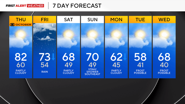
Thursday feels like a prime summer day in Pittsburgh before a cloudy, and possibly rainy, weekend

Our big highlight when it comes to the weather is Friday's line of rain (and some rumbles) that will move through starting in the morning hours.
I have rain arriving in Pittsburgh around 9 a.m. There is a chance for a brief shower ahead of the main line after 6 a.m. If you're up along I-80, rain showers will be possible as soon as 5 a.m., but will only be isolated at that point. By 7 a.m., the main line should be moving in for places like New Castle up in Lawrence County.
The rain will stick around through business hours, with rain ending around the evening rush for communities along the Pennsylvania Turnpike like Somerset and Fayette counties. Friday Night Lights looks to be dry but damp and windy. If you are planning on heading out to one of the games, make sure you're bundling up.
Friday highs will only hit the low 70s in the morning ahead of rain, with temperatures dropping after around 10 a.m. for the rest of the day.
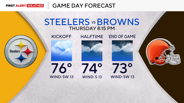
Steelers Game Day Forecast: The Cleveland NWS has rain arriving after 2 a.m. I have it there by midnight, and new data I think is probably siding with the earlier arrival of rain. Temperatures will be in the mid-70s for the game. 4th quarter (especially going up if the game goes to overtime), rain can't be ruled out. The leading edge will have some lightning, so delays are also possible.
Let me get back to today; we will likely see the most sunshine from start to finish of any day this week, with plenty of sun in place for this afternoon. This should help to push highs into the low 80s.
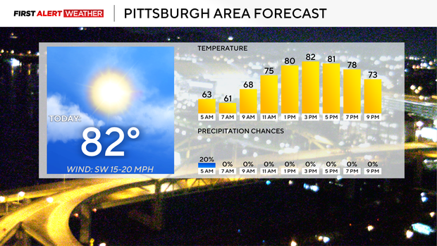
I have Pittsburgh hitting a high of 82°. There were some morning showers up along I-80, but that will come to an end before sunrise. Noon temperatures today will be in the upper 70s. Winds will be out of the south-southwest at around 10 mph. Sunset today is at 7:03.
Friday highs should hit the low 70s, with highs hit before 10 a.m. I would not be surprised if our high temperature for the day fails to hit 70 degrees, with us just briefly in the 70s as the rain arrives.
I may drop those temperatures after looking at more data. Winds will be breezy to gusty, coming in from the northwest after 10 a.m.
The weekend will be cooler, with highs both on Saturday and Sunday near 70 degrees. Another front sweeps through late Sunday into Monday morning. While Friday's rain is the only rain that data is showing, I am putting in a 20 percent rain chance late Sunday into Monday as the cold front comes through.
The front will dip temperatures into the low 60s for highs on Monday and just into the upper 50s for highs on Tuesday. We could potentially be dealing with fairly widespread frost on Tuesday or Wednesday mornings up in the I-80 corridor.
I have Pittsburgh lows near 40 degrees both mornings, with temperatures at or below 37° along I-80 and up in the Laurel Highlands. Temperatures return to more seasonal levels beginning on Tuesday afternoon and remain that way for the rest of the week.