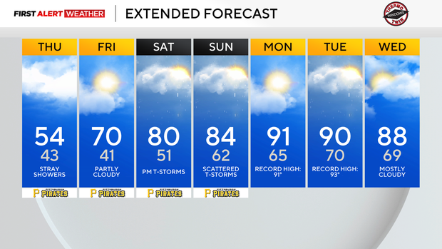
Thursday afternoon in Pittsburgh will have the coolest temperatures over the next week

While cool today, record-setting heat is expected to arrive early next week. Just be prepared, as A/C units are going to be kicking on for a couple of days. Record right now that could fall:
- Pittsburgh Record High - Monday, Tuesday
- Dubois Record High: Monday, Tuesday, & Wednesday
- Morgantown Record High: Monday, Tuesday
- Wheeling Record High: Monday, Tuesday
Each one of these cities will see forecast highs within 2° of the current record high. Some of these records, like Dubois' Monday & Tuesday highs, look to be almost a sure thing. Other ones, like Wheeling's record high, are less certain. Either way it goes, it's been some time since we have seen temperatures this warm, and I keep saying that these temperatures are going to be warmer than what many are expecting.
While it's basic information, this is the time to get prepared for a good 60 hours of really hot weather that will be similar to what we can expect during the summer.
We are still stuck in a cool pattern for today and tomorrow morning.
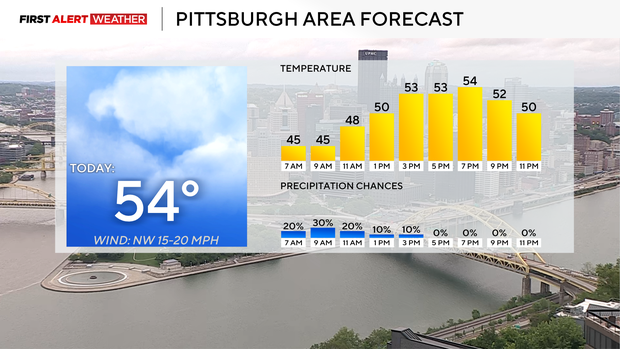
I have today's highs hitting just the mid-50s. Morning lows on Friday morning will be near 40. Highs on Friday will then jump up to near 70. Today will also see a morning drizzle and a light rain chance, along with breezy conditions that will last into the afternoon.
It's going to feel cooler than the already mild at best 50s. It's certainly long-sleeve and hoodie weather.
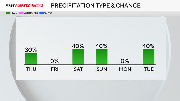
This weekend, we will continue to see the start of the warm-up with highs hitting the low 80s on both days. There will be a chance of a storm around, and at this time, it seems the highest chance for any rain or storms will come north of Pittsburgh, both on Saturday and Sunday.