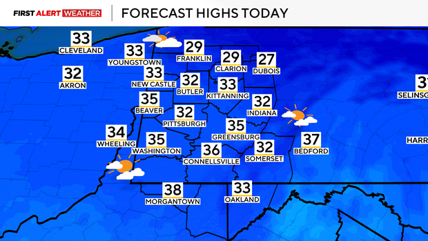
Temperatures will be returning to near normal in the Pittsburgh area today

Temperatures will be returning to near normal in the Pittsburgh area today after several days of bitter cold weather.
While temperatures are still well below normal this morning, we are beginning to come out of the core of this Arctic air mass that has gripped the region over the last several days.
High pressure is located over Virginia and North Carolina this morning, and the clockwise and divergent wind flow around this feature will allow most of Western PA and Northern WV to see southwesterly winds today and tomorrow.
High temperatures as a result will reach the lower 30s today with a few locations getting above freezing south of Pittsburgh.
Temperatures tonight into Wednesday morning will be in the lower 30s and upper 20s as winds remain breezy helping to mix some relatively warmer air aloft down to the surface.
Highs on Wednesday will reach the low 40s with mostly cloudy skies. A weak disturbance may trigger some isolated showers during the midday to early afternoon, especially across the western and northern portions of our forecast area.
Southerly winds will increase in earnest on Thursday ahead of a deepening area of low pressure moving our way from the Midwest. This system has trended a little slower which means more of Thursday will be drier and the best chance of rain and gusty winds holding off until later in the evening and especially overnight.
Up to 1/2" of rain is expected for most of our area which will be beneficial considering how dry it has been across our area this year. We expect substantial melting of our snowpack as well.
High temperatures on Friday will occur early in the day with most spots in the lower 40s, then drop into the 30s for the rest of the day. Some of the rain will transition back to snow on Friday as colder air moves in. Lake-effect and terrain enhanced snow showers could lead to minor accumulation near and north of the I-80 corridor and in the Laurel Highlands and Ridges.
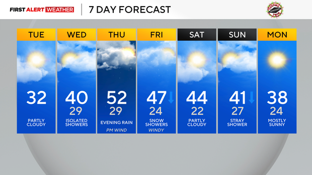
While temperatures will be cooler behind this storm system, this cold air mass will not persist as the large scale weather pattern does not favor any sustained Arctic air moving into the region—possibly even past Christmas.
WEATHER LINKS:
Current Conditions | School Closings & Delays | Submit Your Weather Photos