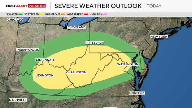
Storms possible Monday afternoon in the Pittsburgh area

It's a KDKA First Alert Weather Day, as storms are possible in the Pittsburgh area on Monday afternoon.
The highest chance for severe weather on Monday will be from 4 p.m. through around 9 p.m. tonight as a cool front slides by. The front will likely be the trigger for strong winds, large hail and even tornados.
The rest of the day should be uneventful and nice enough for kids to get outside to play. Just be aware that if the kids have outside practice, conditions could change quickly this evening, giving parents little to no notice before those strong winds roll through.
While there is a chance of a severe storm later today, most of today will be dry. Not only will it be dry but warmer too.
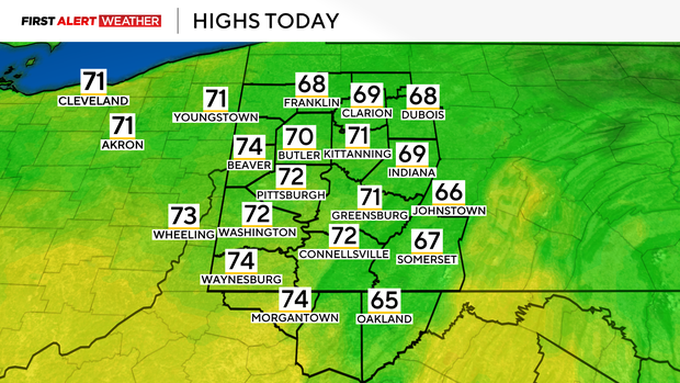
I have our high hitting 72 degrees and morning temperatures are near 50 degrees. Midday temperatures will be in the mid-60s, warmer than it was at any point on Sunday.
Skies today will be mostly cloudy with a couple of brief breaks in the clouds this afternoon. Winds won't be too bad today, coming in out of the southwest at around 10-15mph.
Temperatures will begin to fall behind today's severe weather chances with Tuesday's high temperature being hit at midnight tonight. For the day on Tuesday, temperatures will be in the 40s.
On top of the temperatures in the 40s, wind speeds will be gusting into the 30s and 40s. There will also be light rain and even snow around throughout the day. Model data hints that this may be our last winter weather system of the season if you're wondering.
The weather pattern is conducive to much warmer weather being in place for the rest of April.


