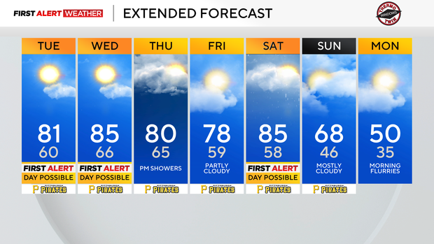
Storm chance remains today as temperatures remain above-average in the Pittsburgh area

Daily average High: 62 Low: 40
Sunrise: 6:44 Sunset: 7:59
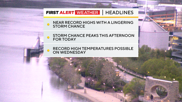
Any Alert Days Ahead? Today is still a potential FAWD due to a strong storm chance for the afternoon. We may need to go into First Alert Mode for the afternoon. Wednesday and Saturday are also potential FAWDs due to strong storms
Cooler weather will return early next week. The GFS is hinting at snow flurries for Monday morning.
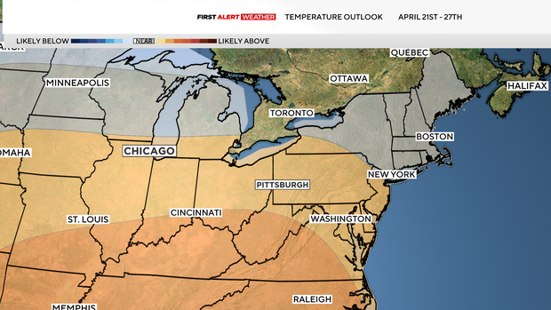
The climate prediction center is showing temperatures slightly above normal for the week of the draft (21st - 27th) and near normal for rain. A cold weather trend is continuing, and at this point, severe weather chances look low for the event. High uncertainty remains.
Severe weather chances stick around for another day today, with highs hitting the low 80s. The Storm Prediction Center has us as a level 1 out of five when it comes to storm coverage. That means most won't see any severe weather. New this year is an intensity scale, and we haven't added to it today, meaning any storms we see would barely hit the threshold for 58 mph or greater winds or 1 inch or larger hail. Storm chances will be highest this afternoon. At this time, windstorms are the most likely issue we would have. Along with strong winds, any storms that develop will likely bring frequent lightning and downpours, which could briefly cause ponding on roads.
With the storm chance low for most of the day, I hope you can find the time to get outside and enjoy the weather. Highs today will soar again to the 80s. The average high for this time of the year is just 62 degrees. It's so warm that our morning lows are starting near the average high temperature. The record high for today is 86°. I have Pittsburgh hitting 81° for today's high. Skies will be partly cloudy, and similar to yesterday, it will be breezy. Sunset is at 7:59.
Temperatures remain warm enough for record highs on Wednesday. I have Wednesday's high reaching 85°, and that is the same as the record high for the day set all the way back in 1883. Temperatures will remain warm through Saturday, with our temperatures crashing on Sunday behind a cold front. The GFS is hinting at snow flurries on Monday morning, and the trend for next week is cooler, with every new data point bringing temperatures down.