Wind chills will reach into the single digits as Pittsburgh is in for a stretch of cold weather
What a difference a day can make.
Yesterday morning, we woke up with temperatures in the mid to upper 40s and some light rain around. Temperatures this morning are in the teens with wind chill values in the single digits at times.
WEATHER LINKS:
Current Conditions | School Closings & Delays | Submit Your Weather Photos
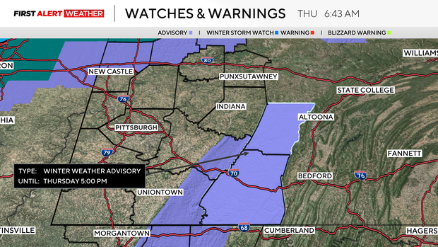
The rapid cool down, along with rain, caused some evening and early morning issues due to slick roads. The 'flash freeze' is tough to handle as road crews have very little time to treat roads in the window between rain ending and temperatures dipping below 28°. Scattered snow showers are expected to stick around through the rest of the day.
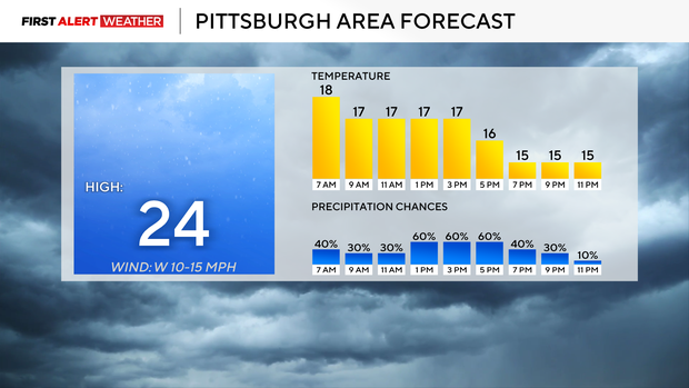
The other big story this morning is temperatures that have already dipped to the teens, and that is where they will be through the rest of the day. Wind chill values are near 0°, and that's where they will stay for the rest of the day.
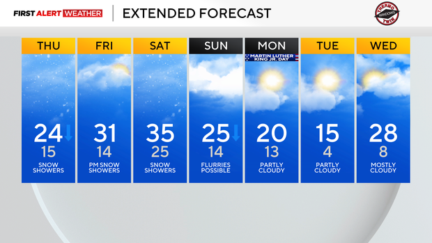
Looking ahead, the timing of Friday's snow is still a little up in the air, with it looking like it arrives late into the afternoon and evening. Some data is pushing Friday's snow chance into Saturday.
Either way, if you are planning on heading out Friday evening through sunset on Saturday, you should be prepared for a quick burst or two of snow. Snow showers will be heavy enough to briefly cover area roads.
Now that the cold is here, it isn't going anywhere anytime soon.
Over the next week, I have Saturday as the warmest day of the week with highs hitting the mid-30s. Most of the next week will see temperatures in the 20s for highs.
The coldest day of next week will be on Tuesday, with daily highs only hitting the mid-teens. On the flip side are daily lows. I have two days of the next week with wake-up temperatures below 10 degrees.
Every other day will see morning lows dipping to the teens. Again, it is looking very cold.
Stay up to date with the KDKA Mobile App – which you can download here!