Severe weather possible this weekend in Pittsburgh, bringing gusty winds and large hail

Who hasn't tried to make a recipe and it didn't turn out how you expected? More importantly, you feel you followed the instructions perfectly, and it still doesn't look like what the picture on the box looks like? That's how I approach severe weather at times.
Looking at Saturday, all the ingredients are there. To be honest, we are already in a little trouble because some of the ingredients we have aren't exactly as much as the recipe still calls for, but we can still "make it work." Hey, we work with what we have, right? At this point, we are in the baking phase of the recipe, and we won't know until around 7 p.m. tomorrow if things turned out how they are supposed to (severe weather happens) or if something was so off that we don't see much.
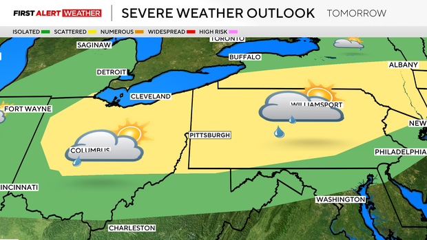
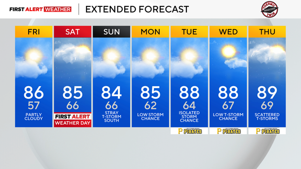
Saturday is a First Alert Weather Day due to said ingredients being in place for severe weather. As a ridge of high pressure begins to break down, we will see a line of storms along and ahead of a cool front that slides through.
The peak chance for severe weather will come from 4 p.m. through 10 p.m. We are currently shaded as a level 2 (out of 5) severe weather risk with destructive wind, large hail, and even tornadoes being possible. It isn't exactly unusual for parts of our area to be included the day before as having a slight risk of severe weather. The extent of the area highlighted as being in a slight risk is a bit unusual. The slight, level 2 out of 5, risk covers almost all of Pennsylvania and Ohio.
The slight risk of severe weather also extends through around half of New York, stretching over to Boston. Model data is still struggling to get an accurate handle on what will happen tomorrow, but as we get a better picture, we may see some spots getting a bump up to a level 3 out of 5 risk level
Getting back to today's forecast, while temperatures will be in the hot range, dew points will stay low, meaning it is going to feel pretty good still.
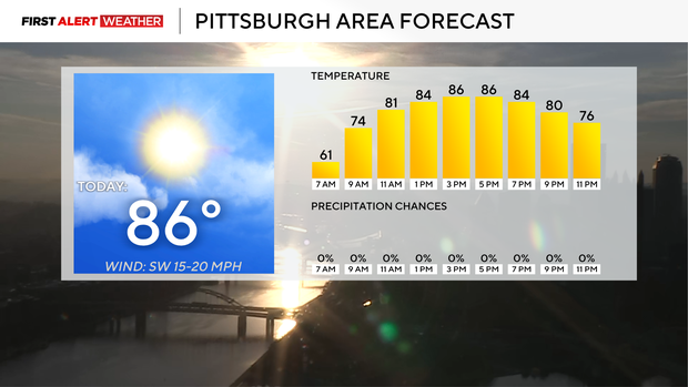
This week has been a case study in why temperature is just part of the equation when it comes to how comfortable you are during the summer. Dew points are now in the low 50s, so they are higher than the 40s we've seen earlier this week. Dew points will increase to near 60 on Saturday ahead of the afternoon and evening storms.
I have highs today hitting 86° in Pittsburgh. Noon temperatures should be in the low 80s. We should see plenty of sunshine this afternoon with light winds coming in from the
Looking ahead, Sunday is looking dry and pleasant. Highs on Sunday and Monday should be in the mid-80s.
After that, temperatures will jump to near 90 degrees for the rest of the week.