Severe storm threat in Pittsburgh with possibility for hail and tornadoes Thursday
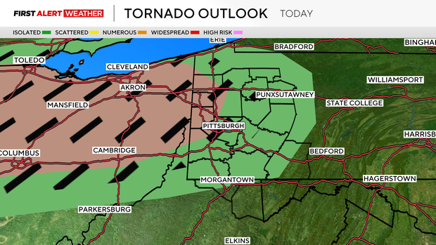
Severe storms are possible today, with the peak chance for stormy weather occurring after 7 p.m. through 11 p.m. Large hail and tornadoes will be possible along and ahead of a line of storms.
Everyone will see rain. Some will see severe storms rumble through. The good news is that before 7 p.m., most will be dry with just an isolated rain and storm chance. Temperatures will be in the pleasant range, so hopefully many can get outside and enjoy.
Today's storm chance is due to a short-wave trough that is moving on the northern edge of a surface trough anchored over Oklahoma. The shortwave will dig down to the southeast through the day today, arriving here in Western Pennsylvania this evening and bringing the chance for storms.
New, updated sounding data won't be out until later this morning, but data based off of the last sounding are showing an environment only marginally conducive for severe storms, including SARS sounding analogs (basically something that looks at the current expected conditions and looks for past severe weather soundings for matches) that aren't showing too many historical matches to severe weather events.
The HRRR is the only model I am seeing that is showing a couple of 'loose' matches for both tornado and hail events of the past. All model soundings yesterday were finding at least a couple of historical comparisons, so we are down from that. What does that mean for you? Not much.
Everyone should remain vigilant this evening and aware of what is going on with the line of storms that will roll through.
So let's take you through the day.
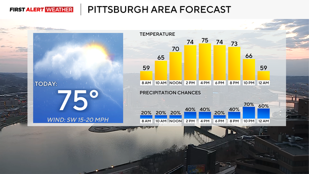
This morning you'll be dry with temperatures in the 60s. I have your noon temperature right at 70 degrees. Temperatures will be warm to hot this afternoon with winds fairly gusty, coming in out of the southwest at 10-15 mph. There will be an isolated storm chance for the afternoon, but most will remain dry. A line of storms comes together beginning at 6 p.m. up along and just north of I-80. This line will begin to move to the southeast.
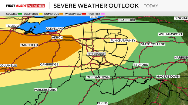
Any storms out ahead of the main line will pose a large hail and tornado risk if they begin to rotate. We will then again have a severe weather chance due to straight-line wind, hail, and a tornado risk on the leading edge of the main line. Rain totals will likely be around 0.75" on average, with places that see stronger cells seeing upwards of 1.5" of rain.
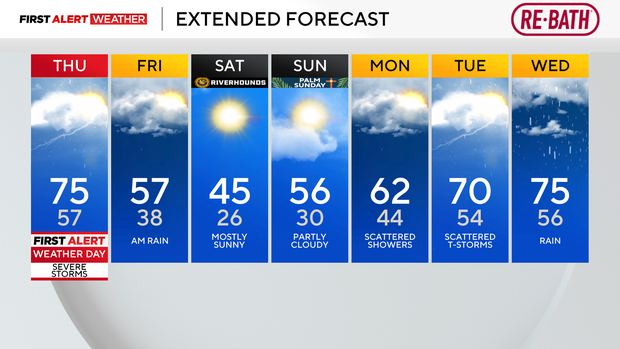
Behind the storms, rain continues through sunup on Friday south of I-70. Friday morning temperatures will again be in the 50s, with afternoon temperatures in the 40s.
Temperatures will be cooler on Friday and Saturday, with Saturday morning temperatures in the mid-20s. We then begin to warm up with highs in the 50s on Sunday and 60s on Monday.