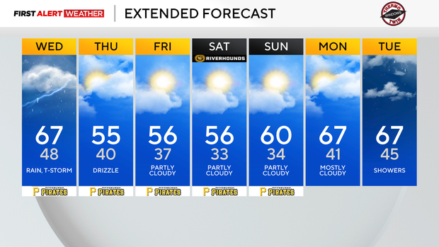
Rain and thunderstorms move into Pittsburgh on Wednesday afternoon

Rain will be on the radar for a big chunk of your day today.
The biggest concern is going to be two periods where we may see severe weather due to strong straight-line winds. Right now, the highest impact with weather will likely come between 3 p.m. and 5 p.m. as strong storms rumble through.
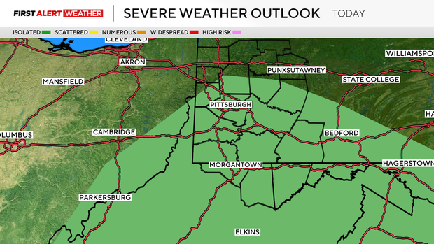
Lots of lightning, isolated downpours, and the risk of strong straight-line winds are the biggest concerns right now. Frequent lightning and downpours will also be possible, with the highest frequency coming on the leading edge of both rounds of rain that are expected.
Temperatures will be dependent on the rain today. I have us quickly seeing the 60s this morning before rain moves in. We should again hit the 60s this afternoon, ahead of the second round of storms that are expected.

This afternoon's storm chance will be the highest chance for severe weather today. Behind the afternoon push for rain, temperatures will again dip to the 50s, and we won't hit 60 degrees or higher until Sunday at the earliest.
Thursday, Friday, & Saturday will be cooler with highs in the 50s and lows falling to near 40 degrees each morning in Pittsburgh.
There will be a low chance of rain in the form of drizzle. Skies will be mostly cloudy overall during this time with mid-level winds rolling in from the northwest.
This weekend is also the Pittsburgh Marathon, and right now it is looking comfortable for area races with highs near 60 and morning temperatures bottoming out near 40 degrees.

Right now, Sunday is looking dry.