Rain chances return to Pittsburgh area, snow could fall over the weekend
Today's sunset time is at 6 p.m. It's the first 6 p.m. sunset of the year, with us seeing sunsets of 6 p.m. or later all the way through October. Enjoy the longer days!
WEATHER LINKS:
Current Conditions | School Closings & Delays | Submit Your Weather Photos
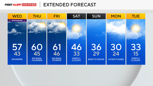
Longer days go hand in hand with warmer days, right? We are starting to see some warmer weather working its way into the forecast, with today, Thursday, and Friday all looking at temperatures well above the seasonal average.
Highs today should hit the mid to upper 50s, with highs pretty close to 60 degrees on both Thursday and Friday.
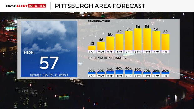
While warm, rain chances are set to return today. It doesn't look like it will be a lot, with most seeing less than a tenth of an inch of rain today. There remains a low storm chance, with places north of Pittsburgh having the 'higher' chance for seeing a storm or two.
The highest chance for rain and storms this week comes late on Thursday into Friday morning. Rain totals should be around a half inch for most places, but there will be scattered reports of more than an inch of rain coming down.
Those larger rain totals will come from places that catch a thunderstorm or two, along with places where training rain, where a line of rain and storms runs parallel to a place, causing rain totals to be higher than surrounding communities, occurs.
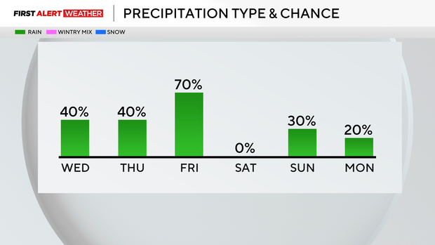
Finally getting into Sunday, snow chances are way down at this time. I don't expect the snow chance to return for the day, but I will caution that model data has not been consistent at all on when and where a potential snow track is going to set up this weekend. Until the model data is consistent with this weekend, I can't be 100 percent sure that we won't see accumulating snow.
It is unlikely that we will see anything more than a light dusting of snow on hard surfaces at this time.
Stay up to date with the KDKA Mobile App – which you can download here!