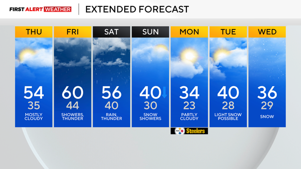
Pittsburgh's warmer weather trend continues through the weekend as highs climb into the high 50s
And just like that, the snow is gone.
Now obviously, there are still some signs of all of the snow that was in place over the past week. Those giant snow piles in some parking lots won't be going anywhere anytime soon, but most of the snow is gone from your yard.
WEATHER LINKS:
Current Conditions | School Closings & Delays | Submit Your Weather Photos
You'd have to travel north of I-80 at this point to find areas with an average of more than an inch of snow on the ground. The warm-up continues through Saturday.
Today will see highs hitting the mid-50s after highs only hit 48 degrees yesterday.
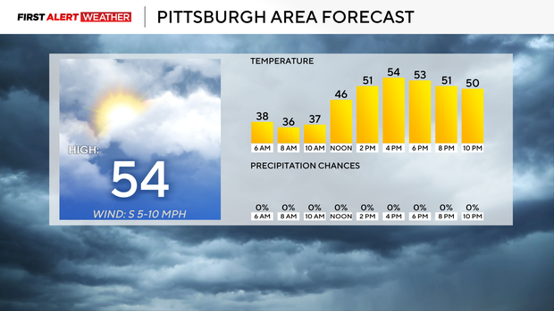
Today's high is a little misleading as it was hit at midnight, with temperatures ticking down to the mid to low 40s for the rest of the day. I was expecting to see temperatures dip to the low 30s this morning, but as of this writing, we are on pace to see lows dipping to just the mid-30s.
Highs today should hit the mid-50s, with us seeing most of our warm-up this afternoon. I only have noon temperatures in the mid-40s. The best chance to see sunshine today happens before 10 this morning.
Rain chances return tomorrow, but most of the day is expected to be dry with several 'waves' of rain rolling through. I have Friday's high hitting 60°.
There's a better chance we hit 60 degrees than we don't. Saturday's rain will be heaviest southeast of Pittsburgh. That's where we could see up to a half inch of rain.
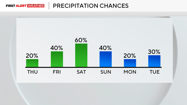
Everyone else probably won't see more than a quarter of an inch. Sunday will be our 'transition' day, with temperatures dropping. Windy conditions are expected for the morning. Light snow will likely pose a minor nuisance for area drivers.
The weather for the rest of next week will be cooler.
Stay up to date with the KDKA Mobile App – which you can download here!