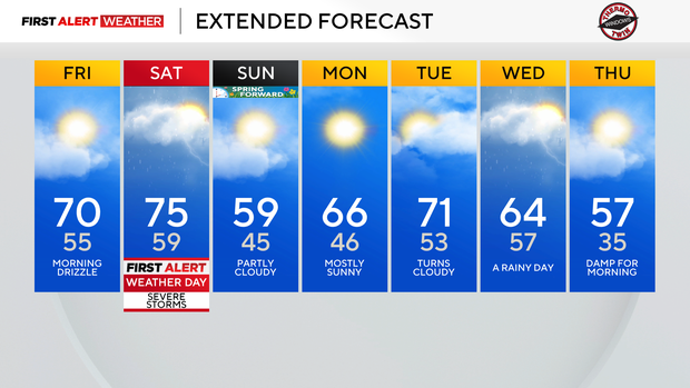
Pittsburgh will see near record-high temperatures on Friday and Saturday
Warmer weather is in place today and Saturday. After the cold weather of the weekend, days like today and Saturday are extra sweet.
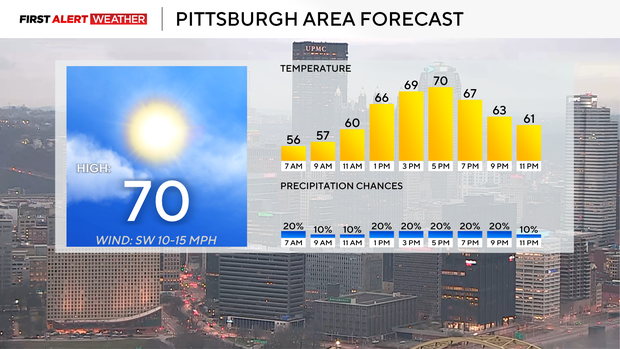
Getting into today's forecast, I can't rule out a passing shower or two before around 1 this afternoon. The morning hours will be foggy, with partly cloudy afternoon skies. Drizzle will also be possible at the start of the day.
Morning temperatures dipped to the mid-50s, but that's already a good 10-15 degrees warmer than our average high today. We won't be setting a record today in Pittsburgh for how hot it gets, but we won't be too far off.
The record high today is 74°, set in 1946. That was 80 years ago. I have the noon temperature in the mid-60s with light southerly winds. Afternoon skies should be partly cloudy to mostly sunny.
Saturday's record high temperature is 76°, set in 1983. I have us hitting 75° for the daily high, but we could easily end up higher than that.
Most of Saturday will be dry, but there is going to be a severe weather chance.
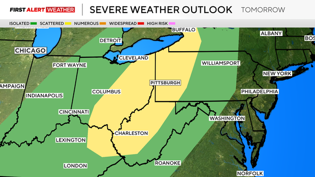
The severe weather will come from a chance of strong windstorms during the afternoon. Both 'singular discreet' cells along with a line of storms will be possible during the afternoon. When it comes to instability, it doesn't look like we will see a lot in the way of instability on Saturday with model data, but there are signs that data may be underplaying instability.
We will keep a close eye on it. Saturday morning temperatures will be near 60 degrees.
A cold front sweeps through just after midnight on Sunday, with highs for Sunday hitting at midnight.
Temperatures for the rest of Sunday will hover near 50 degrees with sunny skies. Not too bad for this time of the year. Monday is looking dry with highs in the mid 60s. Tuesday highs will hit the low 70s, with our biggest rain chance day coming on Wednesday, with some areas potentially seeing more than 1.5" of rain coming down.
Wednesday highs will be in the mid 60s.