Wildfire smoke continues into the Pittsburgh region along with multiple storm chances

Thursday begins on a very warm and smoky note across most of Western Pennsylvania and Northern West Virginia. Wildfire smoke and haze have mixed down to this surface, resulting in code yellow to code orange air quality, meaning that the condition of the air is unhealthy for those with any underlying health conditions.
WEATHER LINKS:
Current Conditions | School Closings & Delays | Submit Your Weather Photos
This wildfire smoke and haze will continue to be in place across our area through 2-3 p.m. this afternoon before thunderstorms develop. The outflow winds from these thunderstorms should finally help to stir up the atmosphere a bit and mix out the smoke.
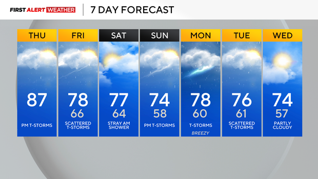
Ahead of the storms, high temperatures will easily reach the low to mid-80s, which is a few degrees above normal for this time of year.
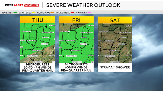
Speaking of storms, the SPC has most of our area in a level 1 out of 5 severe risk for today and tomorrow. Storms should form in the increasingly moist air ahead of a cold front and a weak disturbance moving in from the northwest. We should see development around 3 p.m. Thursday, with the highest coverage generally in our northwest zones, although some models suggest there could be simultaneous development in the Laurel Highlands and Ridges as well.
Initially, coverage will be isolated, but as storm tops collapse and weaken, this may spawn new development in different areas.
Storm coverage should diminish after 8-9 p.m. with only scattered showers overnight, but another disturbance moving in during the mid-morning hours of Friday will likely re-ignite storms during the midday and afternoon hours.
There will not be a ton of wind shear today and tomorrow, so these will be more pulse-like, disorganized storms with a localized "microburst" wind threat along with hail. Winds could gust upwards of 60-70mph in isolated spots along with pea to quarter-sized hail.
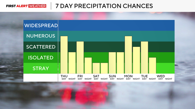
The cold front will eventually sag south into the region by early Saturday with a chance of early morning showers. Most of Saturday into Saturday night is trending drier as we will be in between systems. On Sunday, moisture will return north ahead of a strong low system and cold front poised to arrive on Monday.
We could see storm chances increase as early as Sunday afternoon, with the higher chances moving in on Monday. This system will have much stronger winds aloft accompanied by sufficient moisture and some instability, so we will need to keep an eye on the severe weather threat with next Monday's system.
Lingering showers and storms will continue on Tuesday, before a cold front moves in, resulting in drier conditions by the following Wednesday.
Stay up to date with the KDKA Mobile App – which you can download here!