Pittsburgh Weather: More Storms Expected As Laura's Remnants Move Closer For Another Soaking Of Western Pa.
PITTSBURGH (KDKA) -- Strong to severe storms are firing up once again today across the area.
The most serious alert so far has been a Tornado Warning for Fayette County, which expired at 4 p.m. The areas expected to be most heavy hit during the storm are to the southeast. Forecasters were watching Ohiopyle, Farmington, Markleysburg, Confluence and Henry Clay Township closely.
WATCH: Kristin Emery and Mary Ours on the Tornado Warning --
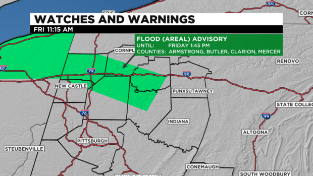
Meanwhile, the National Weather Service has extended a Flash Flood Warning for Allegheny, Indiana and Westmoreland counties until 6:45 p.m.
Severe Thunderstorm Warnings for Fayette and Washington counties have been allowed to expire as well.
KDKA Meteorologist Mary Ours says the biggest threat from these storms are damaging winds and hail.
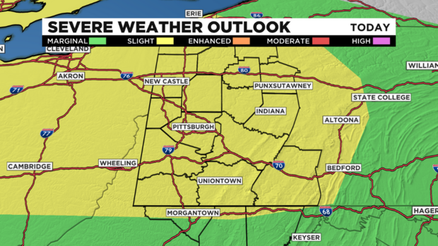
Highs today will be in the mid-80s and it's still humid.
WEATHER LINKS:
Current Conditions | School Delays & Closings | Local Radar | Weather App | Photos
Remnants of Laura move in tonight and continue through early Saturday, possibly bringing another inch of rainfall. There may even be some thunder with the rain but there's no severe weather threat for Saturday. Higher totals of rainfall will stay mainly south of I-70.
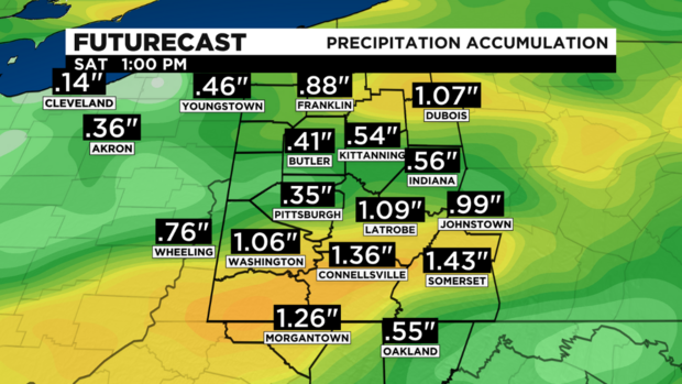
Rain moves out Saturday afternoon and comfortable dry air arrives for Sunday and Monday with highs near 80!
Stay up to date with the KDKA app, which you can download here.


