Pittsburgh in for warmer temperatures on Wednesday, but the windy weather sticks around
Over the past 24 hours, we have seen a big flip in model data when it comes to what to expect next week.
WEATHER LINKS:
Current Conditions | School Closings & Delays | Submit Your Weather Photos
The GFS long-range global model had us fairly warm this weekend, with the warmth sticking around through much of next week. That has really flipped over the past 24 hours. One of the best ways to talk about the change is with what happens at the 850mb (pressure) level.
While the exact height above ground level varies, the 850 mb level's temperature is a great way to look at the movement of cold and warm air, which we call advection. Today's 850mb temperature is around -2°C. Saturday's the warmest it will be at around 11°C. Next week's 850mb temps are now looking to be from -4°C to -6°C.
Yesterday's numbers for next week were all positive except for Monday. This is a huge change that not all models have jumped on. The Euro remains the most consistent long-range model, keeping 850mb temps not only in the positive range but pushing temperatures into the low 70s for highs.
At this point, the Euro model just doesn't look likely, with most data really pointing to another big cool down. I expect the Euro to follow the GFS and others in bringing temperatures down.
So what does this mean for you?
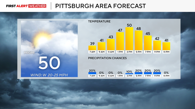
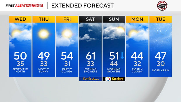
Not too much will change going through Saturday. I have bumped up high temperatures today to near 50. Yesterday I had our high temperature at 45 for today. That's a BIG change.
While there is a small chance for some light sprinkles today, our next GOOD chance for rain happens late on Saturday evening. This is faster than it looked like yesterday, with rain not expected to drive until Sunday afternoon. The rain will be along a cold front that will bring cooler weather our way now on Sunday.
Yesterday? Sunday was the warmest day of the week, with the faster arrival of cold air; it now looks like Saturday will be the warmest of the week. Temperatures will be falling throughout the day on Sunday, with temperatures for most of the day dipping down to the 40s.
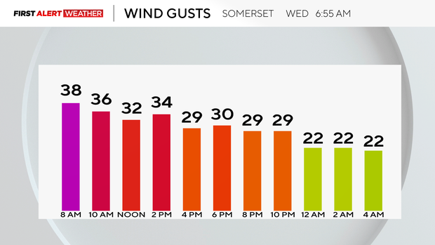
Looking at your forecast, today will be windy once again with highs up near 50 degrees. Noon temperatures will be in the mid-40s with just an isolated shower chance from Butler County to the north. Winds will be strong, coming in out of the southwest at around 15-20mph. Wind gusts could be as strong as 35mph later on today for most, with gusts of up to 45mph possible in the Laurel Highlands.
Thursday and Friday temperatures will be very similar to today, but winds will be a lot calmer.
Stay up to date with the KDKA Mobile App – which you can download here!