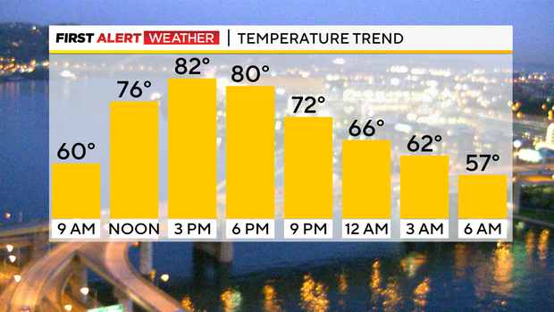
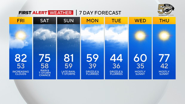
Pittsburgh Weather: Temperatures stay in the 80s, isolated evening showers possible
PITTSBURGH (KDKA) - Yesterday's record high for Pittsburgh was just 84 degrees and we had a real shot of hitting it.
Right now it looks like the high for the day will be 82°. Dubois did set a record high yesterday, hitting 82°. The record had stood for just nine years as they hit 81 in 2014. The record hit for Pittsburgh today is 86° set in 1883.
WEATHER LINKS:
Current Conditions | School Closings & Delays | Submit Your Weather Photos
We won't be hitting that.
Getting into the forecast, we will start to see some things changing today including cloudy conditions moving in for the afternoon and an isolated rain chance returning with the best chance for rain coming in the evening hours and for places south of I-70.
This is the part where I get to tell you that I am holding back on the forecast for today. Model data shows little to no rain impacting us today, but you can see a well-defined mid-level low drifting toward us with radar this morning.
While the center of rotation as of 4 a.m. this morning was located just east of Jackson, MS, rain showers are occurring as far north as Kentucky and West Virginia due to this system. Model data is already underplaying the rain, so it is easy to see where we could receive more rain than what data show for us today.
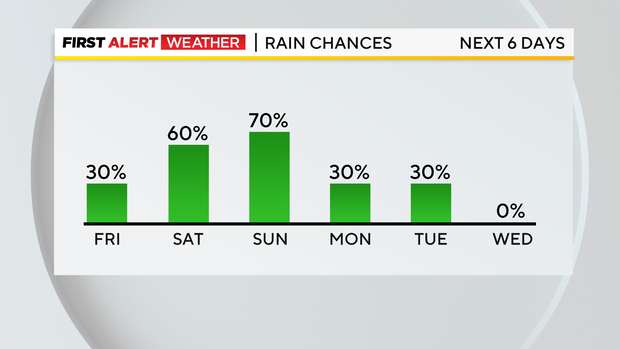
This is a 'tropical' system in the sense that it is carrying very warm and moist air and transporting it north. I wouldn't be too surprised to see us seeing scattered rain today and more widespread rain on Saturday.
I am keeping us in the isolated chance for today but I do have us in the widespread to scattered rain range on Saturday. Model data has also come up on expected rain on Saturday.
Just a quick mention of what to expect on Sunday as we have a powerful front that will drop through. This will bring us not only rain but a severe weather threat due to strong winds.
Stay up to date with the KDKA Mobile App – which you can download here!