Pittsburgh Weather: Rain chances increase throughout the next week
PITTSBURGH (KDKA) - The chilly weather pattern isn't quite done just yet.
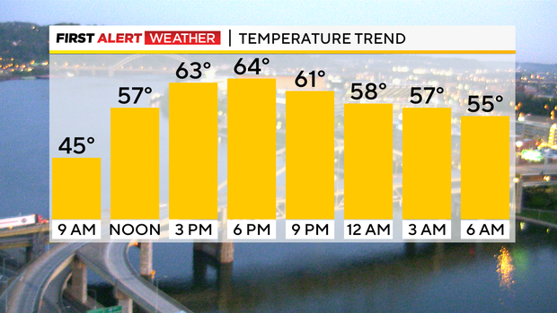
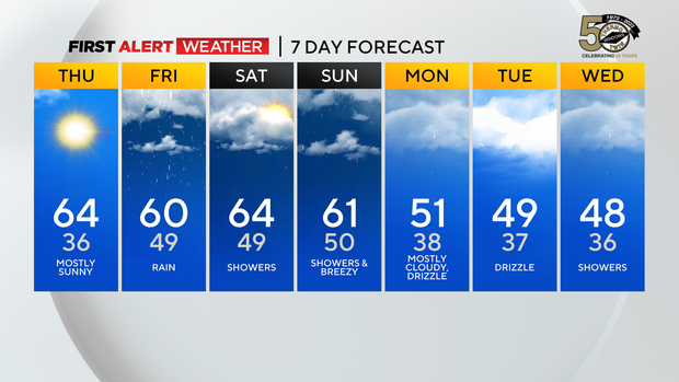
I say that before talking about a brief warm-up starting this afternoon and continuing through the weekend with highs hitting the 60s and morning lows in the 40s and even 50s in some cases. With the warmer air returning we will also have a chance for what looks to be mostly rain showers starting at midnight tonight and continuing for quite some time.
WEATHER LINKS:
Current Conditions | School Closings & Delays | Submit Your Weather Photos
In fact on the seven-day outlook, today is the only day that doesn't have a rain icon on it.
Tomorrow's rain chance will come from a mid-level low that is currently located in western parts of Arkansas. This is the same system that brought large hail to parts of the Dallas, Texas area yesterday. I am not expecting any severe weather from it here. We may not even get any storms out of it.
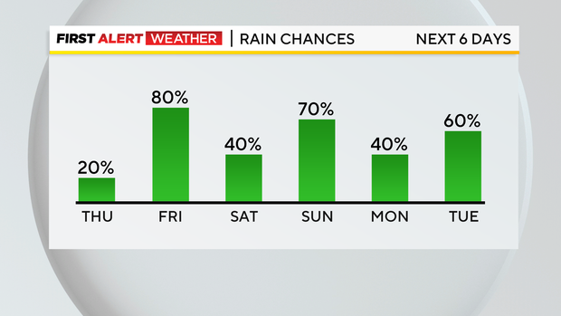
What we will see is moderate rain coming in during the morning commute. The rain should be steady throughout the morning, wrapping up shortly after we head into the afternoon.
Rain totals only look to be around three-tenths of an inch.
Not too bad considering just how long I am expecting it to rain.
In the wake of the mid-level low, we will continue to have spotty scattered showers and maybe even an isolated storm.
This off an on rain chance will continue through the day on Saturday.
This spotty rain will also keep potential energy down for any storm development on Sunday as a cold front associated with an upper low is expected to slam into our region.
With the upper low around, morning lows will again drop to the 30s on Monday and Tuesday mornings.
Stay up to date with the KDKA Mobile App – which you can download here!