Pittsburgh Weather: Morning rain will taper off throughout the day
PITTSBURGH (KDKA) - Wow, what a night on Tuesday with severe storms ripping through the area.
What did you see?
WEATHER LINKS:
Current Conditions | School Closings & Delays | Submit Your Weather Photos
Overall we saw 30 reports with one injury reported as a large tree branch fell in Upper St. Clair. The local National Weather Service office is expected to go out and survey wind damage in Washington County for signs of a tornado sometime today although a final decision won't be made until later on this morning.
Pittsburgh saw an official rain total of 0.64" yesterday. The highest wind gust topped out at 54mph.
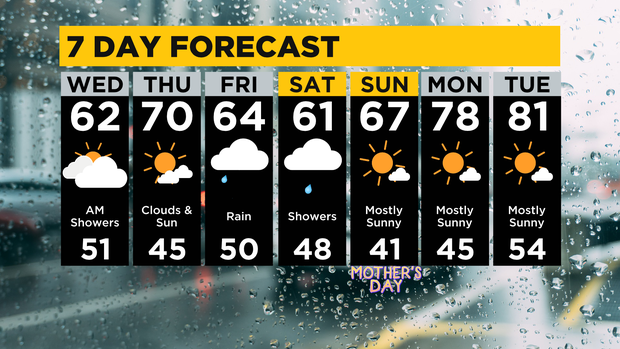
We still have some rain showers around this morning and drizzle may stick around into the early afternoon as we continue to see the atmosphere cool behind yesterday's cold front. Skies will be cloudy and it's going to look like it is going to rain at any given moment throughout the day.
Daily low temperatures won't be reached until just before midnight tonight.
Morning temperatures should tick down from near 60 to the mid-50s through the morning hours before finally ticking back up to the low 60s for the afternoon. Winds out of the west at around 10mph won't help it feel any warmer through the day. It's going to feel cool through the day.
Looking ahead, the sun returns on Thursday with a nice looking day and highs hitting 70.
We should begin to see clouds rolling in during the late afternoon hours with rain chances returning on Friday morning. Friday will see rain showers through the day with rain rates picking up as we head to the evening and overnight hours.
Rain will continue through Saturday morning with rain pushing east by 2 p.m. on Saturday. The rest of the weekend will be dry.
I have us hitting 64 for a high on Friday and a high of just 61 on Saturday. Both mornings will see lows near 50. Sunday's high will likely hit the upper 60s.
Stay up to date with the KDKA Mobile App – which you can download here!