Pittsburgh Weather: Latest dry stretch ends this Friday
PITTSBURGH (KDKA) - Today will be the 7th day in a row with no rain recorded in Pittsburgh. We've only seen 0.05" of rain so far this month - the drought maps are out this morning at 8:30.
WEATHER LINKS:
Current Conditions | School Closings & Delays | Submit Your Weather Photos
We are now halfway through the month of November and so far we have seen just 0.05" of rain. It's the third driest start to November on record and driest since 1964.
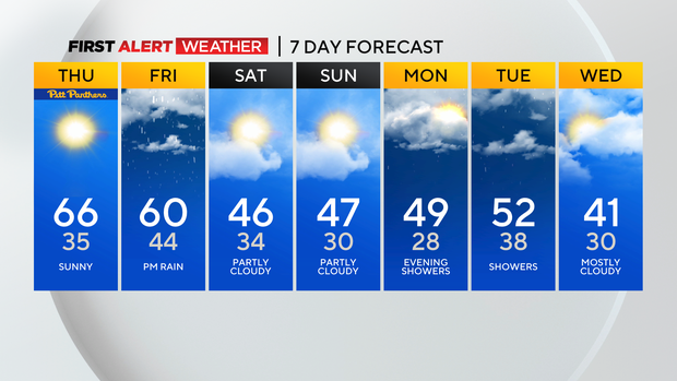
Rain is expected to arrive Friday afternoon; with rain wrapping up by sunrise on Saturday. Rain totals on Friday will likely be around three-quarters of an inch.
Snow showers may linger through noon on Saturday but are expected to be isolated at best.
More rain, and snow, are expected to roll through from Monday evening to Wednesday morning. While we won't make up our total deficit in rain over the next week, the inch to an inch and a quarter I am expecting to fall will certainly help things.
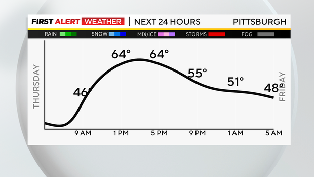
While we wait for the rain to arrive I guess we will have to make do with a chilly morning but pleasant afternoon weather pattern.
Today is the last day of this pattern with morning lows dipping to the mid to low 30s in most places and highs in the mid to maybe even upper 60s today.
Today's record high in Pittsburgh is 71°. That puts the record just out of any reasonable chance of being broken today. I have noon temperatures in the low 60s.
The skies will be mostly sunny and we will see more sun than we did yesterday.
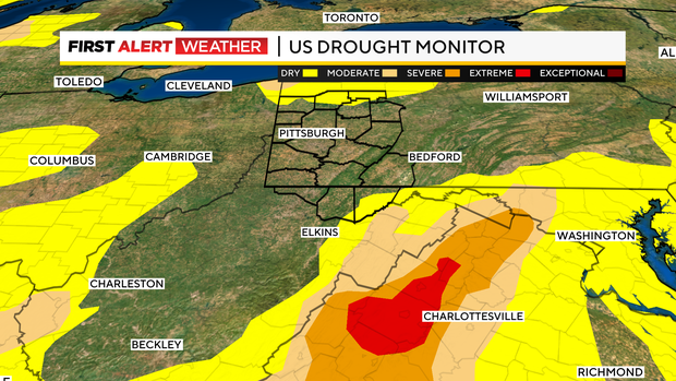
Drought maps are out at 8:30 this morning. We may see parts of our area being added to the abnormally dry zone. Places in Virginia certainly need rain more than we do with a large section of their state looking at severe to extreme drought conditions.
Stay up to date with the KDKA Mobile App – which you can download here!