Parts of the Pittsburgh area could see snow this weekend, but most will see a wintry mix or rain

The Pittsburgh area is expected to see its first snow reports of the season this upcoming weekend for higher elevations.
Any alert days ahead? Nope
Aware: Measurable snow expected for highest elevations late Friday into Saturday morning.
The impact for most will be minimal. The best chance for snow will come between sunset on Friday and sunrise on Saturday. This is when we will have the best chance for precipitation, along with the coldest temperatures in place for snow creation. The airmass above the surface will be VERY cold. Our snow 'melt-line' (the point in the atmosphere where snow is melting to rain droplets) is going to be extremely low. Maybe even less than 100 feet above the surface in Pittsburgh. Depending on how dry the air is at the surface, we could see snow 'frost' over, creating graupel (ice pellets).
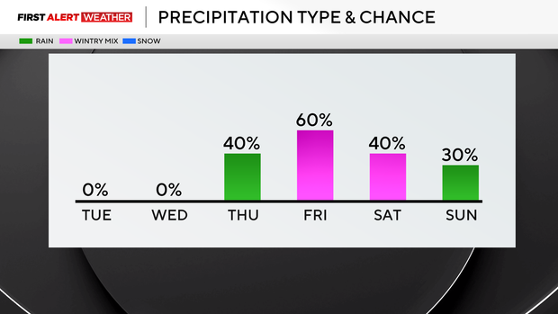
The best news right now is that temperatures are expected to remain right at or just above 32° for most of this event. The ground is warm, so any ice pellets that reach the surface should melt quickly, and icy road conditions should not be a widespread issue. Can I guarantee there won't be a slick spot or two out there? No. Be especially wary of places with leaves on the road. Conditions are not conducive to icy roads, though, and for most people this will be a cold rain event.
Higher elevations will see some snow, including the chance for accumulating snow. We will get into potential snow totals beginning tomorrow. The GFS model is still being very aggressive with its snow outlook. The EURO is much more conservative, with barely a dusting of snow for even the highest elevations. Both models do bring a very cold air mass in place, with 500mb to 1000mb thicknesses coming in well below 540.
Getting back to today's forecast, highs today should return to the 60s with plenty of sunshine both in the morning and afternoon. Highs today should hit the mid to low 60s. I have Pittsburgh's high at 63°. Noon temperatures should be in the mid to upper 50s.
Clouds return on Wednesday just after sunrise, with morning lows in the mid to upper 30s. Highs on Wednesday will be near 60°. Rain arrives on Thursday morning with light rain possible for the rest of the day on Thursday. Temperatures will cool on Friday, setting up the winter weather chances for Friday and Saturday.
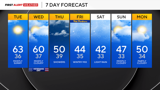
The upper low, the cause of our weekend cool-down and winter weather chance, will move out on Sunday, with Sunday afternoon looking dry.