It's going to be a cool week for the Pittsburgh area, but snow could arrive this weekend

It's going to be a cool week for the Pittsburgh area, but snow could arrive to the region this weekend.
Any alert days ahead? Nope.
Aware: No more sunrises before 7 a.m. for the rest of the year.
We will start off with partly cloudy skies, with clouds thickening up for the afternoon.
Clouds will be thickest to the northeast today as a trough continues to cut through the state. I had highs today back in the mid-50s but slightly lower than yesterday's 57° high. I am forecasting a high of 56° in Pittsburgh.
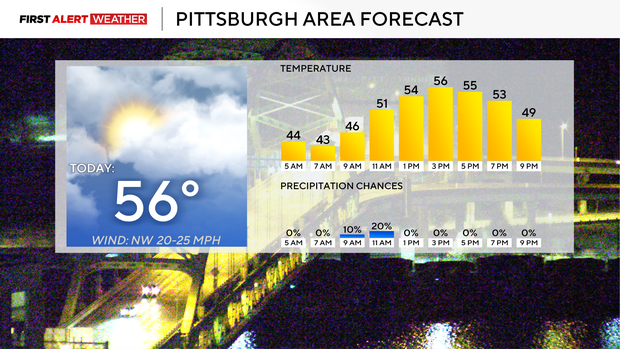
Morning temperatures are in the mid to low 40s. Noon temperatures will be in the low 50s. It'll be another breezy day with wind gusts past 25 mph.
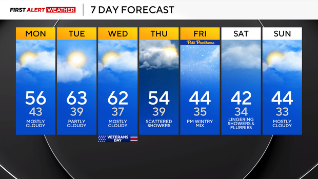
Highs should be in the 60s on Tuesday and Wednesday, with morning lows near 40. Rain chances are back for Thursday, sticking around through the weekend.
Let's get into the weekend's snow chance. The biggest issue right now with any potential snow is going to be with surface temperatures, with highs expected to be in the low 50s and mid to upper 40s on both Friday and Saturday.
Sunday highs will be in the mid to low 40s. Low temperatures are expected to hover near 32°. Higher elevations will see lows bottoming out in the mid to upper 20s. With temperatures where I am expecting them to be, we are really looking at a wintry mix for most, with just wet, not slick, roads.
We will need to watch temperatures closely in higher elevations, where we could see accumulating snow.
The GFS model continues to show respectable snow totals, but the other main long-range model (EURO) has just rain for the weekend. The EURO is probably the model closest to what will likely happen.