Pittsburgh to see impact from Hurricane Isaias this weekend as rain is expected

It's tough to include too many details when it comes to hurricanes in the morning blog because details constantly change while this write-up goes live every morning online around 8 a.m.
Locally, our impact from a 'post-tropical' Isaias will be rain and more rain. We will actually see our first changes later today, with high clouds sliding in from the south beginning this afternoon. We will remain cloudy Saturday and most of Sunday too.
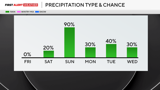
It does look like our window for rain has sped up, with rain arriving around midnight on Sunday and the steadiest rain happening from around 4 a.m. through around 11 a.m. While the Steelers game was looking all wet yesterday at this time, there is a chance now that most, if not the entire game, will be dry.
The rain chance will be highest in the first half. Long-range model data has been fairly steady with rain totals, with the GFS continuing to forecast higher totals than the EURO. The GFS is forecasting most seeing around 1.5" of rain. The EURO is probably closer to what we should expect, pumping out just over an inch of rain, with the heaviest rain happening over around a 5 to 8 hour period. This should limit our flood risk, but pooling water on roads will be possible, as on any rainy day. Winds aren't looking that strong, with wind speeds of around 15 mph on Sunday and gusts up to 30 mph being possible.
While we wait on the rain, today will be another fantastic day with sunny skies before 4 p.m. I have highs today hitting 70 degrees. Yesterday we hit 71° for our daily high. I have noon temperatures in the mid to upper 60s. Winds will be out of the west today at around 5 mph.
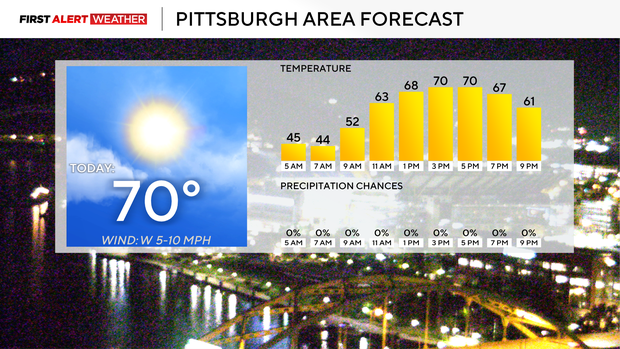
Saturday will see high clouds in place through the day, with highs hitting the mid-70s. Saturday is looking dry, but I do put in a small isolated rain chance for southern communities, and that would be as we watch the leading edge of Isaias moving into our region. Saturday morning lows will be in the 40s in most places, with noon temperatures around 70 degrees.
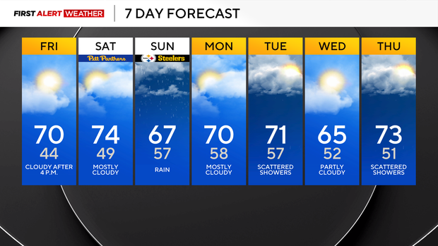
Next week, behind the storm, temperatures will remain warm for this time of the year for the work week, but data is showing a cooldown heading our way for next weekend. There will also be a couple more chances for rain in the middle of next week, with scattered showers expected Tuesday and Thursday.
While I will keep our hurricane talk fairly general, this will have everything you need to know when it comes to what to expect from Hurricane Isaias.
As of 3 a.m, Isaias is a Category 2 storm with sustained winds of 105 mph. It is forecast to become a 'major' Category 3 storm sometime this morning and should maintain winds of around 115 mph until shortly before landfall this evening around 7 p.m. near Pensacola, Florida.
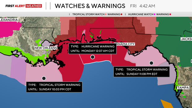
Interest along the coast from the Mississippi outlet in Louisiana all the way over to Tampa Bay will see some coastal flooding and erosion with unsettled seas. Parts of the Florida Panhandle and Alabama will see plenty of rain, with inland flooding also being possible. This area is fairly flat from the Ocean inland, so flooding could be fairly extensive.