The warmer temperatures continue the snow melt in the Pittsburgh area
Expect damp roads this morning as you head out to work or school. Even with yesterday's 0.4 inches of rain, road "dampness" is more likely due to snow melting off.
WEATHER LINKS:
Current Conditions | School Closings & Delays | Submit Your Weather Photos
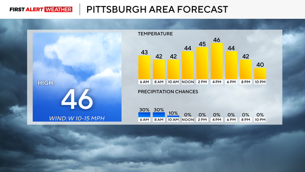
While today won't see highs as warm as yesterday's 51° day in Pittsburgh, temperatures will remain well over the freeze point through the day.
Model data and surface reports show most snow south of I-80 has melted off, with an average snow depth of just over an inch north of I-80. Morning temperatures were in the mid to low 40s, and highs today will get back to the mid-40s.
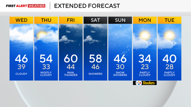
I have Pittsburgh seeing a high of around 46 degrees this afternoon. Pittsburgh's daily low of around 39 degrees won't be hit until just before midnight tonight. Temperatures will dip all the way down to the low 30s overnight.
Looking ahead, the warm-up will continue tomorrow after the brief pause today. I have highs hitting the mid-50s on Thursday.
Highs will be up near 60 degrees on Friday and Saturday. We will transition to more seasonal weather on Sunday with a high of around 46° at midnight. Temperatures will quickly fall to the 30s, and that's where we should stay through the afternoon.
Sunday will also be windy with snow showers still expected in spots. The impact of snow should be minor for travelers.
While temperatures will be near 60 for highs on Friday and Saturday, rain showers are also expected from start to finish both days. The best chance for rain during the stretch will come on Saturday morning, with more scattered to isolated showers outside of the Saturday morning window.
Stay up to date with the KDKA Mobile App – which you can download here!