Pittsburgh area sees multiple tornado warnings, flooding after severe storms slam region

The Pittsburgh area saw multiple tornado and severe thunderstorm warnings issued on Sunday afternoon as severe weather slammed the region.
At least three tornado warnings were issued, but the National Weather Service has not confirmed any tornado touchdowns as of 6 p.m. Sunday. A flash flood warning remains in effect until 7:15 p.m. for northern Washington County.
As the storms rolled eastward, power outages also increased throughout the area.
West Penn Power's outage map showed several thousand customers without power as of 6 p.m.
- Westmoreland County: 14,657
- Fayette County: 4,300
- Washington County: 1,918
- Allegheny County: 1,650
- Greene County: 991
- Beaver County: 345
- Butler County: 230
Duquesne Light's outage map showed at least 5,600 customers without power as of 6 p.m.
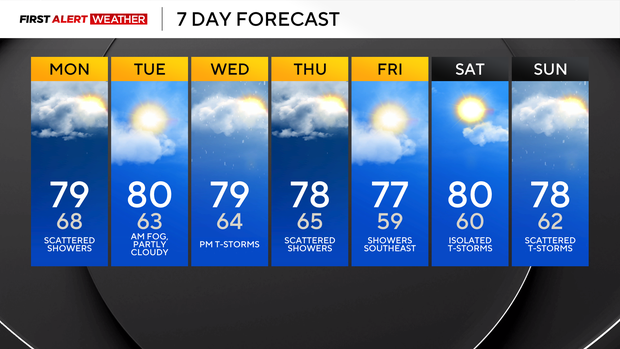
Sunday's forecast is below.
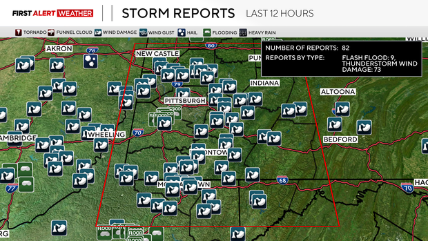
Across the Pittsburgh area, there have been approximately 81 storm reports from this afternoon's linear cluster of storms. Most of the reports range from trees and power lines down to flash flooding.
Since the ground is saturated from recent heavy rainfall across the region, it does not take much of a downburst or that high of a wind to cause damage. There have not been any confirmed tornadoes as of yet, but there were several convincing radar signatures that popped up briefly over south-central Beaver County into southwest Butler County around the Cranberry-Zelienople area.
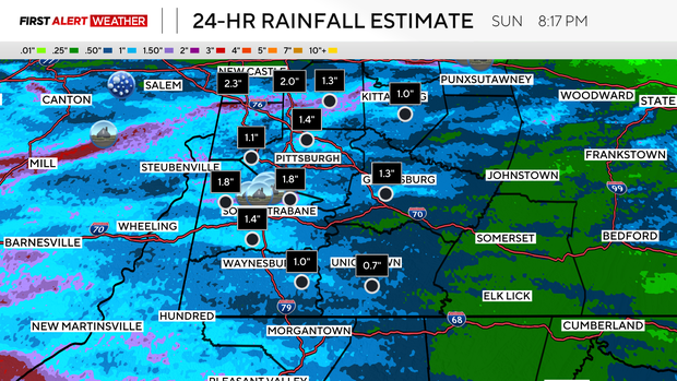
The heaviest rainfall we've seen so far today has occurred in two swaths — one in northern Washington and southern Allegheny counties, with several reports of street flooding from Canonsburg into McMurray.
Another swath of 1 to 2 inches occurred in central Venango County east through southern Clarion County. Incredibly and unusually high atmospheric moisture values contributed to this intense rainfall.
A daily record amount of precipitable water was observed in the early morning and early afternoon weather balloon launches from the National Weather Service Pittsburgh office.
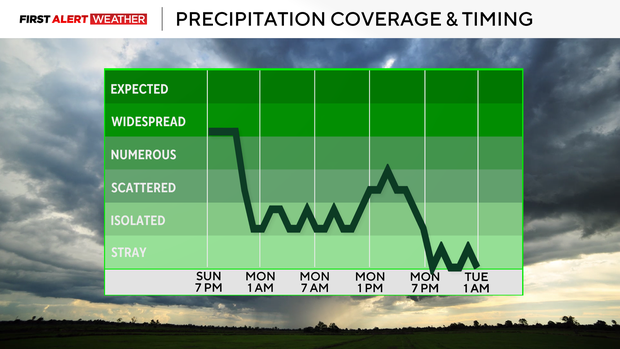
For the remainder of the evening and overnight, showers and storms still ongoing in Ohio will move southeast and generally impact areas south of the I-70 corridor, although there will be some scattered activity north of there into Pittsburgh and the rest of western Pennsylvania.
The afternoon storm cluster has largely removed the greatest instability from our region, so the severe threat is expected to stay low. Skies will be overcast to mostly cloudy Monday morning with high amounts of moisture in the air.
The big change for Monday now is that the cold front is trending to pass through more slowly, likely not until 2-5 p.m., which means we'll carry a risk for scattered showers and storms through the day. Isolated additional amounts of rainfall through tonight into Monday evening could reach 1 to 2 inches in spots.
Drier and cooler air moves in, with the rest of Tuesday expected to be dry and partly cloudy. Winds will shift to the southwest Tuesday night into Wednesday, allowing moisture to return ahead of a cold front. As the cold front and some stronger jet stream energy aloft move, showers & storms are expected during the afternoon and evening hours. A severe storm cannot be ruled out.
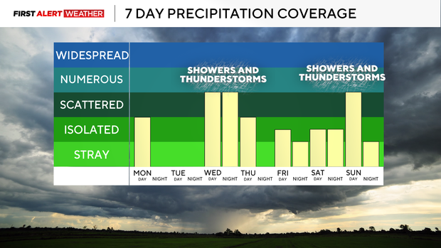
Lingering showers will occur on Thursday, especially during the morning and in our southern counties as the front works its way south and stalls out.
Isolated showers and storms are possible on Friday, especially in our southeast area closest to where the front stalls out. More storms are possible into the weekend as another slow-moving and deep trough moves into the region. Temperatures will largely stay near or slightly below normal for the week ahead.