Pittsburgh looking at its 7th day with no measurable rain

Yesterday's weather was perfectly 'average' when it comes to our monthly data. Yesterday's high was 76°. That is also the average high for this time of the year.
Yesterday's low was 55°, just a degree off from the average morning low for this time of year.
We are in the middle of what will likely go down as one of the best stretches of weather we will see this year. Yesterday's high hit 76 degrees, with the low dropping to the mid-70s. Humidity levels remained low. While temperatures have steadily ticked up over the past couple of days, it has remained comfortable for those outside.
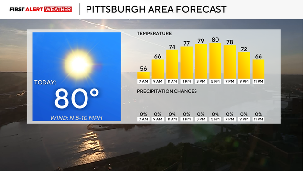
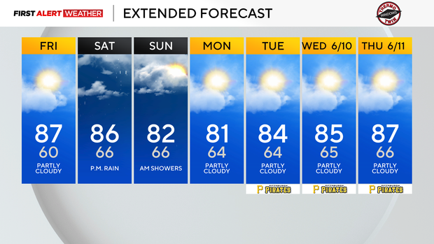
Maybe a tad bit cool in the morning earlier this week. Looking ahead, we have today and another two days before rain returns to our area on Saturday. Highs today should be near 80 degrees with morning lows back in the mid to low 50s. Skies are expected to be cloud-free with light winds coming in from the northwest at around 10 mph this afternoon.
Right now, our weather pattern is being controlled by a powerful 1028 mb high-pressure ridge that is centered directly on top of us today. As the ridge continues to slowly drift to the east, we will increasingly be on the 'warm' and 'unstable' side of the ridge. It's only a matter of time before we begin to see the storms visible to the west arriving here as the ridge continues to break down and move to our east.
At this point, I cannot rule out a passing isolated shower on Friday, with everyone seeing rain on Saturday afternoon. The rain chance continues Sunday morning, with rain chances ticking down for the afternoon.
Overall, I am expecting most to see between a quarter of an inch and a half-inch of rain.