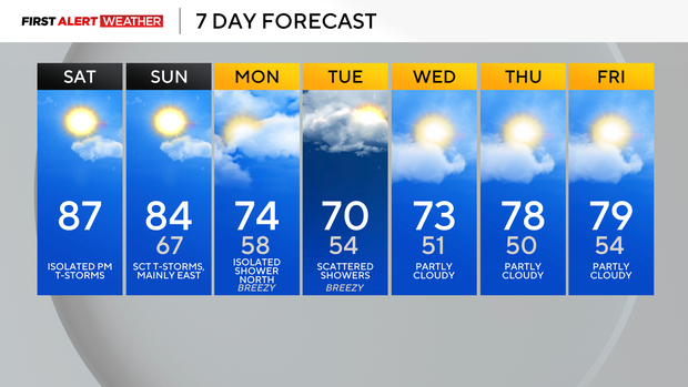
Saturday begins partly cloudy and cool before sunshine and warmth move into western Pennsylvania
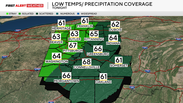
This morning, we begin the day with skies that are mostly clear to partly cloudy and temperatures largely in the low to mid 60s. Through the day, winds will increase out of the southwest, leading to an increase in the amount of moisture and warm air.
WEATHER LINKS:
Current Conditions | School Closings & Delays | Submit Your Weather Photos
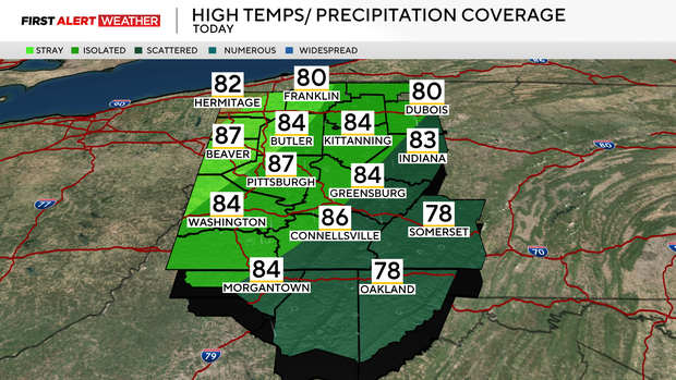
Highs will reach the mid-80s with intervals of clouds mixed with sun. After 5-6 p.m., some of the moisture moving up the westward-facing slopes of the Laurel Highlands will likely trigger some isolated to widely scattered afternoon and evening showers or thunderstorms as a disturbance aloft in the atmosphere moves in from the west.
The precipitation chance drops off west of I-79 as most modeling has the moisture plume tomorrow directed toward areas east of I-79.
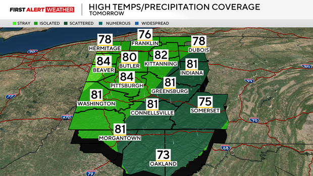
For Saturday night into Sunday, the first of several disturbances will move across the region, keeping the chance for isolated and scattered showers and storms persistent, especially in our east and southeast counties.
Precipitation chances will likely diminish just after sunrise for a few hours as we will be in between systems. The next disturbance to move in will arrive in the afternoon hours—likely after 3-4 p.m., and lead to another round of isolated to widely scattered storms, especially east and south of Pittsburgh, where higher levels of moisture will be in place.
Any thunderstorm cells on Saturday afternoon or Sunday could produce strong to marginally severe downburst winds along with brief downpours.
The actual cold front will pass through on Sunday night into Monday morning with increasing winds and falling temperatures. Cool air will be finishing transporting into the region by Tuesday and Wednesday, which is when we anticipate our coolest daytime highs—generally in the upper 60s to low 70s.
Some lake-effect showers may reach areas north of Rt. 422 on Monday and Tuesday. The coolest mornings for next week will likely be Wednesday and especially Thursday as high pressure settles in, leading to a clearing of skies during the overnight hours.
Temperatures will begin to moderate somewhat by the end of next week as a large trough begins to lift out of the region and milder air flows in from the west, but the large-scale pattern looks to continue to remain fairly dry, which will likely allow abnormally dry and even moderate drought conditions to grow across the area.
Stay up to date with the KDKA Mobile App – which you can download here!