Morning rain in Pittsburgh area increases flood risk for rivers and creeks
Over the last 24 hours, a majority of locations across western Pennsylvania, including the Pittsburgh metro area, have received between 0.25-0.75" of rain. As expected, there have been localized swaths of 1-1.5" of rain, with those generally occurring along a line from Johnstown to Greensburg to Washington.
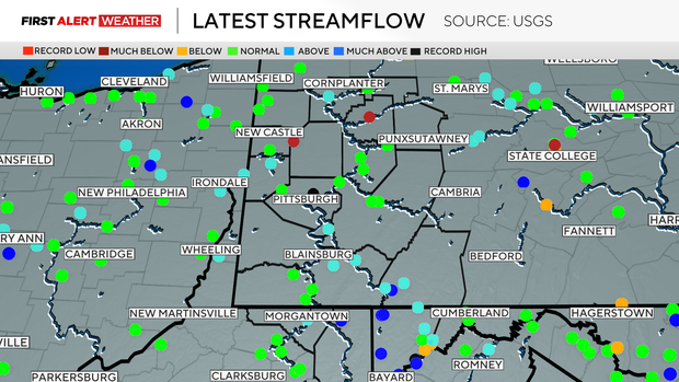
Rivers and creeks areawide are reporting above normal to high streamflow due to a combination of runoff from heavy rain and melting ice and snow over the past week. If you live near a creek or stream that easily floods, be on the lookout for sudden water rise and flooding.
The bulk of the heavy rainfall has exited our area as of 6 a.m. However, the main surface cold front and surface low pressure are still moving across Ohio and Michigan. As those features move east into western Pennsylvania, this will allow the chance of isolated to widely scattered showers and thunderstorms to continue through 1 p.m.
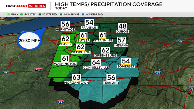
There is a very low risk of severe weather if any cells do manage to pop up along the boundary. Behind the front, strong winds will ensue after 11 a.m. and carry on through the evening hours. Gusts upwards of 40-50mph are likely, which can do minor damage to weakened tree limbs and powerlines.
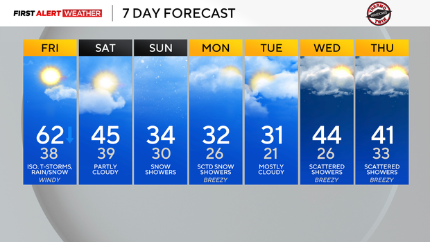
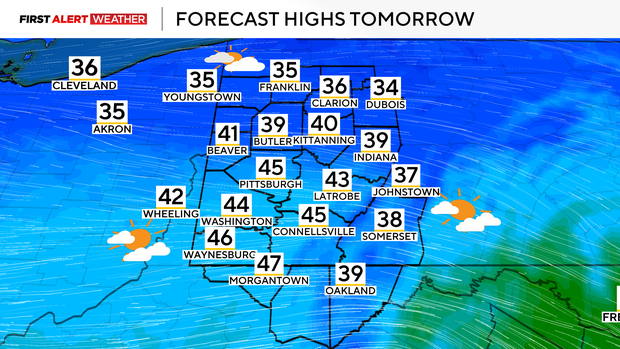
Temperatures will briefly spike into the low 60s, but fall into the 40s this evening—ultimately ending up in the 30s overnight.
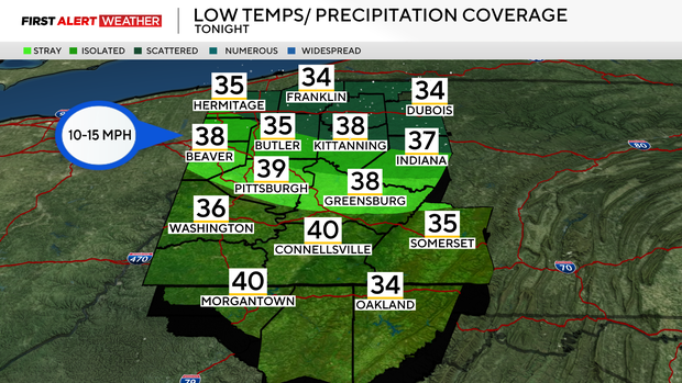
Some snow showers are expected to wrap around the low pressure as it passes to our north between 6 p.m. and midnight. Those will generally affect areas north of HWY 422 toward I-80 with little to no accumulation expected.
A brief lull in the active weather pattern is expected on Saturday as a ridge aloft centers itself over the region. The next storm system will quickly emerge from the Rockies into the Central US and move toward the East Coast by Sunday.
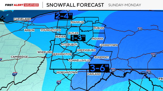
Temperatures will be cold enough with this system to support snow showers across most of western Pennsylvania and northern West Virginia as the upper-level low passes over our area on Sunday into Monday. At the moment, the upper-level features with this storm system don't favor significant intensification of this system until it emerges off the East Coast.
This should, in general, keep our snowfall amounts light to moderate for most of our forecast area with 1-3" west of the Laurel Highlands into the Pittsburgh metro and I-79 corridors. Locally higher amounts are possible in the upslope region of the Laurel Highlands and Ridges with 3-6" in spots.
Temperatures next week will be below normal with highs in the low 30s through Tuesday before warmer winds blow in from the southwest ahead of another series of disturbances expected to bring snow, then rain, on Wednesday and Thursday.