More flash flooding risks in place today for parts of the Pittsburgh area

More risks of flash flooding are in place today for parts of the Pittsburgh area.
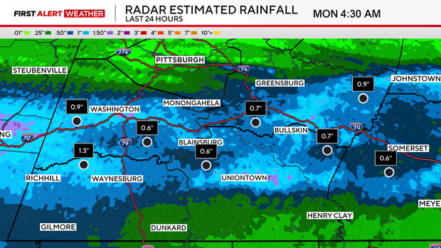
Any Alert Days Ahead? Today is a First Alert Weather Day due to morning flood risk. Tuesday will likely be a First Alert Weather Day due to flood risk, but confidence in the timing of rain is low.
Aware: We are currently just 1.66" away from hitting our yearly average rain total of 39.61" of rain after recording 0.08" of rain on Sunday. Through Sept. 20th, we continue to be on the fifth fastest pace for yearly rain.
I think everyone is ready for a break from rain, and it is coming. It won't happen today, though, with rain chances sliding through the area once again. The highest chance for rain will come today through 10 a.m. Just isolated showers and drizzle are expected for the afternoon. Tuesday will likely be wetter overall, with the potential for some heavy rain from midnight to 5 a.m. in the morning followed by pesky stratiform showers occurring for the rest of the day. Both today and Tuesday will see a morning flood risk, with rain rates in the afternoon not expected to be high enough to cause additional flooding.
Our rainy pattern is expected to wrap up late Wednesday to maybe early Thursday morning. Passing showers during both of these days are not expected to be high enough for any additional flooding issues. Once Thursday afternoon comes, the fall weather pattern remains in place, but it'll be dry. We will be in a peak 'autumn weather pattern' with highs only in the low 70s on the warmest of days. There will be a number of days with highs in the mid to upper 60s. It does appear that model data's trend of pulling temperatures down each and every day has come to an end, and there are only a couple of temperature changes on my 7-day compared to yesterday. It's about time for that.
Getting back to today's weather forecast, it really is a tale of two different areas, with most of the rain occurring from Pittsburgh to the south. Communities north of Pittsburgh will see only light rain and drizzle today, with the coverage area percentage fairly low all day. The further south you are, the higher the chance that flooding could occur. The highest rain rates, coinciding with the highest flood risk, go through 10 a.m. High temperatures have already been reached today, with Pittsburgh seeing a high of 65°. Temperatures will slowly tick down today through around 8 p.m. I have our low coming in at 56°. I don't remember there ever being a case since I have lived in Pittsburgh with falling temperatures through something as late as 8 p.m. and then temperatures ticking up for the remainder of the day, but here we are.
I have Tuesday highs in the low 60s. Model data continues to show another shortwave moving through, bringing another chance for rain rates high enough to cause some flooding with training showers. I have Tuesday seeing a low of 55°
Rain showers will be light on Wednesday, with highs near 60°. Morning lows will be in the low 50s. Most of Thursday will be dry, with rain moving out before sunrise. Thursday highs will be in the mid to low 60s.
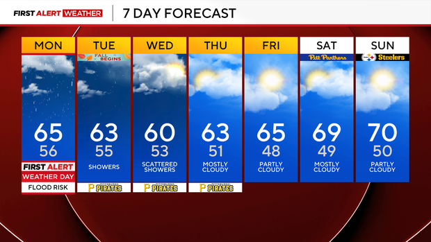
Friday will be dry and pleasant, but some may consider it cool. I have Friday highs hitting the mid-60s. Finally, your weekend is looking dry and pleasant with highs up near 70°. The Great Race is on Sunday, and conditions are looking fantastic for the race.


