How a warming climate is changing lake-effect snow
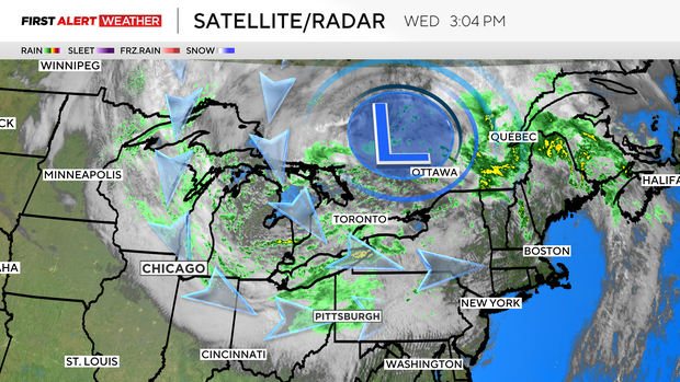
A strong low pressure has parked itself over Ontario, Canada, this week.
This low pressure has occluded, which means it has stopped intensifying and feeding off of low-level warm air from its warm sector and has become stacked with a counterclockwise swirling mass of colder air aloft in the atmosphere. The colder air aloft under the low plus a flow of colder air from higher latitudes in Canada has resulted in our first widespread lake-enhanced precipitation event of the season.
Temperatures are too warm in the lowest levels of the atmosphere to support a lake-effect snow event, so this is predominantly all rain. However, this week's event does prompt us to look at current lake conditions, what may be on the way for this winter, and the future trend of lake-effect snow with respect to a rapidly warming climate.
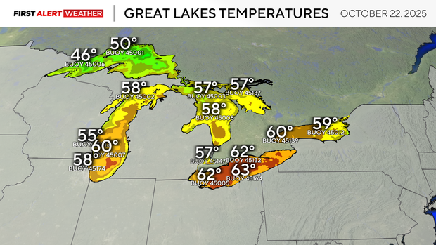
Presently, water temperatures across all of the Great Lakes are running well above normal for this time of year. All five of the Great Lakes are averaging around 4 to 5 degrees above normal for mid-late October, according to satellite-derived data from NOAA's Great Lakes Surface Environmental Analysis center.
This is the warmest the Great Lakes have been since October 2021. Warmer than normal lake temperatures are a part of a long-term trend as Earth's climate continues to warm. Fall and winter on average are trending much warmer with less intense and fewer cold spells.
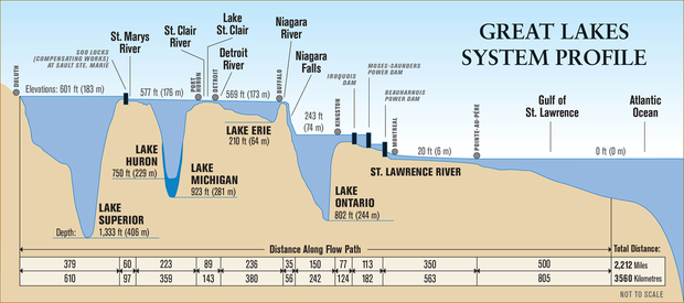
Water has the highest specific heat capacity of nearly all liquids except ammonia, which means it takes more energy to raise the temperature of water, but water can also hold onto energy for a much longer time as well. This means it takes a longer time and much energy must be removed to lower the temperature of water as well. This same principle also relates to the depth and surface area of the Great Lakes and explains why the shallowest lake, Erie, tends to freeze and thaw faster compared to Superior.
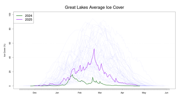
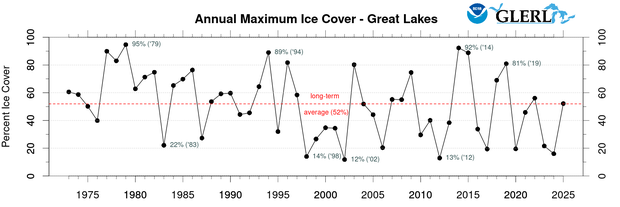
These warmer than normal lake temperatures going into fall and winter accompanied by less intense Arctic air over time are leading to a decreasing annual trend in Great Lakes ice coverage. Winter 2023-24 featured a historic record low amount of ice coverage across all Great Lakes. Winter 2024-25 was colder than 2023-24 which led to more ice coverage, but this is not reflective of the long term trend. Since 2000, the annual maximum ice cover on the Great Lakes has been below the historical average for a total of 15 winters compared to only 9 winters from 1973-1999.
Climate change and lake-effect snow
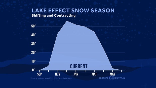
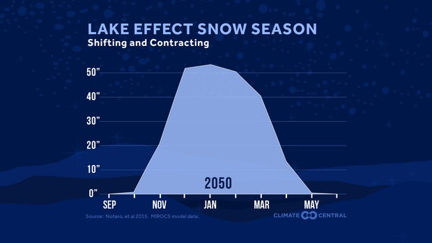
The amount of ice coverage and the time it takes to reach that ice coverage plays a huge role in the intensity and duration of the lake-effect snow season.
As the Great Lakes stay warmer longer with less ice coverage deeper into winter, lake-effect snow storms are expected to temporarily become more intense, leading to a temporary increase in snowfall amounts for areas near the Lakes through the middle part of this century.
The lake-effect snow season is also expected to trend later in the calendar year as well. Historically, lake-effect snow has peaked in the late fall to early winter months, but on a continued warming trend, this would be pushed back later with a shorter peak season deeper in winter. If the trend of air masses continues to be warmer, this would eventually lead to less lake-effect snow in the long term and more lake-effect rain events.