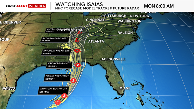
Map shows Isaias' path toward Pittsburgh area, with remnants bringing widespread rain

The U.S. Gulf Coast is bracing for Hurricane Isaias, with remnants making their way to the Pittsburgh area this weekend.
While the risk of flooding for western Pennsylvania is low, rain will be widespread over a roughly 24-hour period. Here's when Isaias will arrive in the region and how much rain is expected.
Map shows Isaias' path to Pittsburgh
The first signs of Isaias will arrive in the Pittsburgh area on Friday. The afternoon will be mostly sunny, but some of the cirrus clouds associated with the outer edges of Isaias will gradually work into the region's southern counties closer to sunset.
While all of Saturday will be dry, skies will trend partly to mostly cloudy as the cloud shield with Isaias and an upper-level disturbance spread into the region. High temperatures will be warmer thanks to a southeast wind and warm air advection pushing temperatures into the low to mid-70s.
The remnants of Isaias will merge with an upper-level low and become non-tropical on Sunday as they move into the Ohio Valley. This will lead to the next chance of widespread rain for our area beginning mid-morning Sunday and lasting through Monday morning.
How much rain will Pittsburgh get?
Presently, most model guidance is in line with 0.75 inches to 1.25 inches of rain areawide. A higher-end scenario would be closer to 2 inches, but this is not the most likely case to occur right now.
The risk of flooding is low due to this being spread out over roughly a 24-hour period, and the lack of thunderstorms should prevent rainfall rates from getting close to flash flood guidance.
As high pressure and a ridge move in behind the departing system on Monday, there will be some early morning showers followed by gradual clearing into the afternoon and evening.
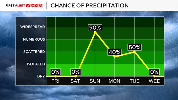
Warm air will quickly surge in on Tuesday out of the southwest ahead of another approaching trough and its associated low pressure and cold front. This will briefly force temperatures back to the low to mid-70s with a chance of showers and potentially thunderstorms next Tuesday afternoon depending on how much instability is present.
A brief cooldown will occur behind this front Wednesday before warm air moves in ahead of another system by late next week.