Intense heat to break Sunday across Pittsburgh area
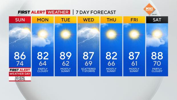
PITTSBURGH (KDKA) -- The intense heat finally breaks Sunday, though it will still be warm and muggy in the mid-80s.
Daily averages: High: 81 Low: 61
Sunrise: 5:50 Sunset: 8:54
Alert: Sunday is a First Alert Weather Day for potential severe storms during the afternoon/evening.
Aware: Heat finally breaks but returns somewhat midweek.
Our heat warnings/advisory should expire at 8 p.m.
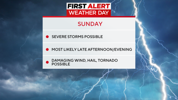
We are tracking the potential for some stronger storms to roll through on Sunday, especially as we head into the afternoon and evening. That rain is associated with a cold front that will bring in some cooler air into Pittsburgh and push out some of that humidity.
Sunday is a First Alert Weather Day, with a slight or level 2 out of 5 risk for severe storms with damaging wind, hail, and a tornado can't be ruled out as well.
For Monday, it will be cooler and less humid, which means it will be far more comfortable!
Monday is expected to be a dry day too, and then temperatures will start to warm up as we head into Tuesday. Another chance for widespread rain comes on Wednesday.
WEATHER LINKS:
Current Conditions | School Closings & Delays | Submit Your Weather Photos


