First hurricane of the season forms in the Gulf, rain heading to Pittsburgh this weekend

Picture-perfect weather will remain in place on Thursday, and I have highs today in the low 70s.
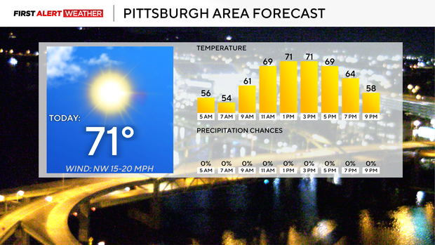
There will be plenty of sunshine from start to finish. Morning lows will be in the mid- to low 50s, with our daily low hitting just before midnight tonight. I have Pittsburgh seeing a daily low of 51 degrees.
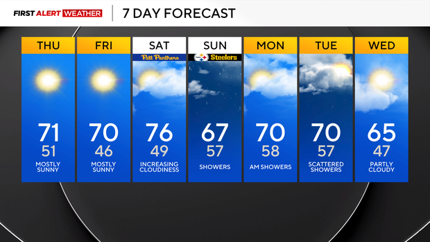
Friday will be very similar to today but slightly cooler in the morning (mid-40s).
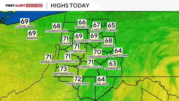
Saturday will probably be the warmest day of the next week, with highs in the mid-70s. The Pitt Panthers are playing at home on Saturday and will see comfy weather for the game.
Rain should begin around sunrise on Sunday due to tropical moisture moving by, with the heaviest rain happening late in the morning into the early afternoon hours.
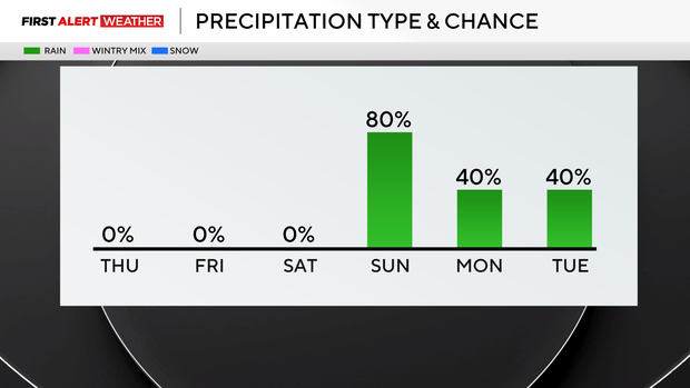
I have Sunday highs in the upper 60s. Rain wraps up on Monday morning, ahead of the morning commute. Highs next Monday and Tuesday should be in the low 70s.
So, here we go: A powerful El Niño global wind pattern has suppressed the tropical storm season in the Atlantic up until now, with us getting our first hurricane of the season in the Gulf of Mexico overnight.
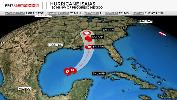
Satellite imagery shows a rapidly intensifying storm with a well-defined "central dense overcast" cloud deck.
As of 3 a.m. I am not seeing an indication of a storm eye, but I'd expect to begin to see an eye of the storm soon. The storm is expected to drift to the northeast over the next day and a half, eventually making landfall somewhere on the Alabama coast. Currently, the official forecast has the storm as a Category 2 storm at the time of landfall, but with plenty of warm air and just moderate shear impacting the storm, this may be too conservative of a forecast.
The Tropical Storm Warning extends from around Grand Isle, LA, all the way over to just north of Cedar Key, FL. Hurricane warnings are in place from around Panama City, FL all the way over to where the Mississippi flows into the Gulf.
While most of the impact from the storm will occur within 25 miles of the coast in the areas just mentioned, the post-tropical moisture from the storm will impact a wide swath of area well inland, including here in western Pennsylvania.
The moisture will move through most of it on Sunday, with the Steelers game now looking wet from start to finish. Model data is showing totals of around an inch to maybe a little more being possible fairly widespread on Sunday. The rotation from the storm will actually pass by on Monday morning, but only light rain will occur after around 8 p.m. on Sunday through Monday, with most of the moisture remaining on the system's northeast flank.