Weather in Pittsburgh will be cooler, but not cold like it's been the last few weeks
We needed yesterday, right? After seeing a stretch of 19 straight days with temperatures at or below 32°, we finally broke through in a big way with highs hitting the mid-50s yesterday for highs. While we do have more 50-degree days on the 7-day forecast, today will be closer to what our seasonal averages are when it comes to highs and lows.
WEATHER LINKS:
Current Conditions | School Closings & Delays | Submit Your Weather Photos
Pittsburgh has already seen our high temperature today, coming in at 38°. Low temperatures today will hit at the end of the day and should be around 26 degrees.
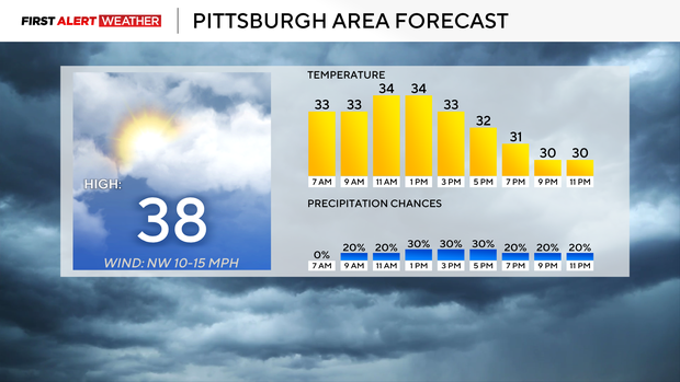
For most, today will be a snap back to a winter reality with overcast skies and wind chills in the 20s for most of the day. It'll be breezy with winds coming in out of the northwest at around 10mph. For those in the higher elevations of the Ridges and Laurel Highlands, you have a Winter Weather Advisory in place through 3 this afternoon.
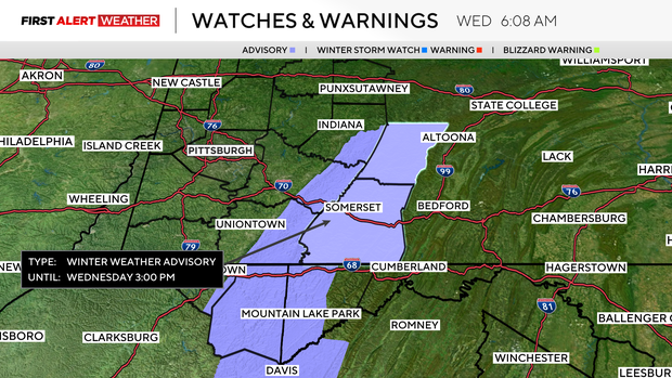
You should expect around an inch of snow and a chance for freezing drizzle up through then.
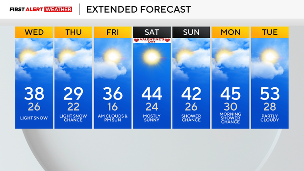
Looking ahead, Thursday will be the coldest day of the week, with us only getting back to around 29 for a high after morning lows dip down to around 22. There will still be a light snow chance on Thursday, with the best chance coming in the morning. Winds will still be breezy, coming in out of the northwest at around 10mph.
Things will start to improve starting on Friday with highs back in the mid-30s. Weekend highs will be in the 40s, and I have a couple of 50-degree days expected in the middle of next week.
When it comes to rain chances, there are a couple of chances over the next week, but there is no model agreement or single model consistency at this time.
We will have a mid-level low that rolls through on Sunday into Monday morning. The Euro model shows our area seeing rain and snow from the system. Even some ice appears to be possible.
The GFS model was showing a small impact from the system yesterday, but has kept the system well south of us for the last few runs.
There is also going to be a chance for rain next Wednesday, but data is inconsistent on what, if anything, we should expect. With warmer weather back in place over the next couple of weeks, any big rain chances will bring a chance for creek flooding.
Stay up to date with the KDKA Mobile App – which you can download here!