Cold front moves through Pittsburgh on Thursday with scattered storms
Today is the day of change many have been waiting for after an unusually hot and very humid stretch of weather across Western Pennsylvania and northern West Virginia. A cold front has moved into the northern half of our area already this morning and has begun to stall out around the Pittsburgh metro.
WEATHER LINKS:
Current Conditions | School Closings & Delays | Submit Your Weather Photos
A trough or shortwave of low pressure in the upper levels will move atop this boundary today, triggering showers and storms as it interacts with the moisture in and around this boundary.
For areas north of HWY 422 toward I-80, these locations will likely experience widespread steady to moderate rain beginning mid-morning through late afternoon. Where the air is most unstable, thunderstorms are expected to develop starting around 1 p.m. and last through the early evening hours, with east and southeast portions of the Pittsburgh metro into the Laurel Highlands most likely to see some thunderstorm activity.
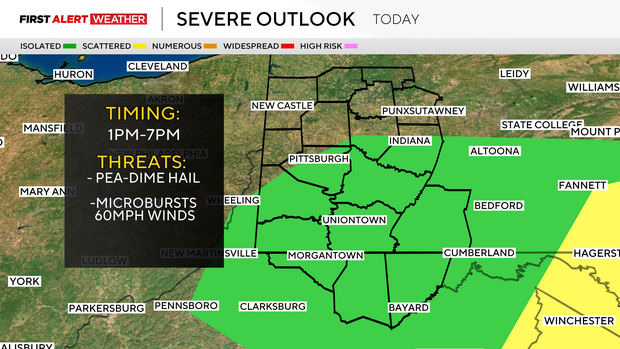
There is some stronger wind shear today, which will help to organize storms to persist a bit longer and be more robust, so hail ranging from pea-sized to dime-sized is possible along with gusty winds up to 60mph. Areas southwest of Pittsburgh will likely have lower coverage of storms due to weaker amounts of lift.
Skies will remain cloudy later this evening into the overnight hours as drier and cooler air moves in behind the advancing cold front.
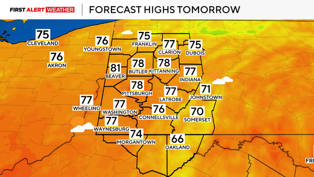
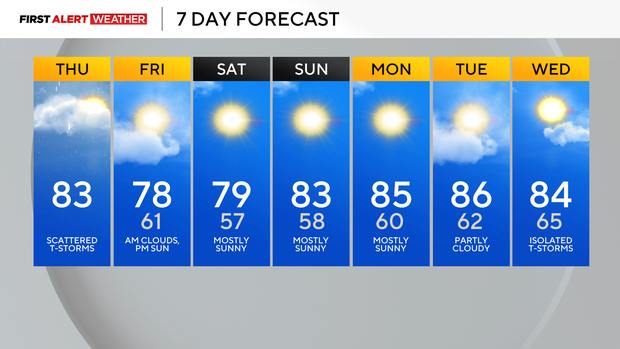
Lows tomorrow will likely end up in the low 60s and upper 50s for most, with highs reaching the mid to upper 70s by the afternoon with clearing skies. High pressure looks to settle in behind the front going into this weekend with daytime highs on Saturday and Sunday near to slightly below normal and lows fairly comfortable overnight in the mid to upper 50s for most.
High pressure will move east of our region slowly next week, allowing the return of warmer air, although moisture levels shouldn't be too unbearable for the first part of the week. Conditions look to stay dry at least until next Wednesday, when the next disturbance approaches from the west with a low chance of precipitation at the moment.
Stay up to date with the KDKA Mobile App – which you can download here!