Another day of pleasant weather on Thursday, isolated rain possible this weekend in Pittsburgh

Pleasant weather will continue today with the cold front now off the East Coast.
The center of the ridge is located to our west, allowing us to see northerly light winds today. I have high temperatures today, hitting the low 80s with sunny skies.
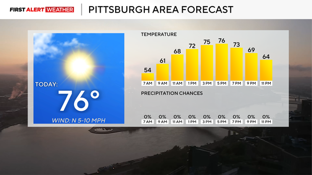
Morning lows dipped all the way down to the low 50s in Pittsburgh, with some communities seeing lows just below 50 degrees. Noon temperatures will be near 70 degrees.
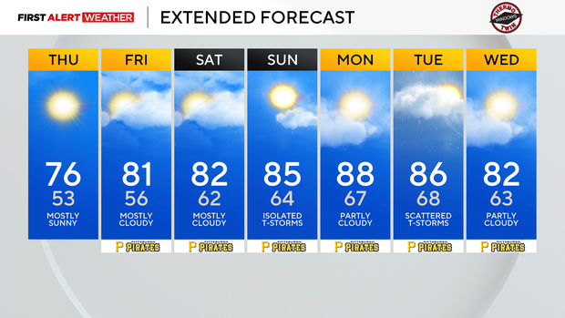
Looking at the weekend, I have Friday dry. I have an isolated rain chance for Saturday, and scattered rain is possible on Sunday.
The weekend will remain comfortable with humidity levels in the low to moderate range. Highs each of those days will be in the 80s.
Tornadoes in western Pennsylvania on Tuesday
They came, they surveyed, and they found three separate touchdowns when it came to Tuesday night's tornado cell that impacted communities right off Highway 422.
The touchdowns were rather short-lived, with the total length on the ground coming in at just under a mile. The first touchdown was the longest touchdown, happening near Villa Maria in Lawrence County. The length of this tornado on the ground was 0.49 miles with a maximum width of 200 yards. Surveyors noticed broken branches near Evergreen Road and partial roof damage on a home near there. This tornado's peak winds are estimated at 80 mph. That gives the tornado a rating of an EF-0. The last tornado to occur in Lawrence County was in May 2021.
The next touchdown was in Portersville in Butler County. This was the tornado that was caught by storm chasers on video, and this tornado was the weakest of the three, with peak wind speeds estimated at 61 mph. The tornado stayed on the ground for just 0.22 miles with a path width of 50 yards. The tornado occurred in a field on Baulder School Road east of Route 19. This tornado was also classified as an EF-0.
The final tornado was the strongest, with estimated peak winds hitting 85 mph. This classifies this tornado as an EF-0 as well. The tornado had a path width of just 30 yards. This tornado occurred near Prospect, PA, along Yellow Creek Road. As you would expect, this final tornado caused the most extensive damage, and even though the track moved past a residential property, it thankfully missed the home. The tornado did uproot two large trees along with causing other tree damage nearby. Survey crews were not able to completely catalogue damage along the storm track due to thick vegetation in spots.
Tuesday's storms were driven by a cold front passing by with upper-level winds favorable for severe storm development. While data indicated one of the higher tornado risks we will see all year, the early arrival of our first round of rain thankfully mucked things up. Conditions remained only moderately favorable for storm growth as skies remained cloudy and highs only hit the mid 70s. This was well below the forecast high for the day of 83°. This meant instability was well below what we expected. Even with an environment with little potential energy for storms, other favorable conditions, including plenty of shear in the atmosphere, allowed this brief tornadic cell. A second line of storms also tried to bring tornadic storms our way but lost its intensity once the sun set.