Strong storms move through Pittsburgh region Saturday

Two powerful lines of thunderstorms are moving southeast across western Pennsylvania as of Saturday evening. Both of these lines should eventually get close to each other or merge as they track southeast of the I-70 corridor.
Some notable storm reports are below.
Clarion, Jefferson counties
- 4:16 p.m. Tornado reported near Summerville.
- 5:04 p.m. Trees down along Route 66 in Limestone Township, four miles south of Strattanville.
- Sporadic tree and power line damage reported near and northwest of Punxsutawney, possible tornado damage.
Westmoreland County
- 5:15 p.m. Derry Township, reports of a funnel cloud around West Third or West Fourth Avenue. No confirmed touchdown.
- 5:30 p.m. Derry Twp, multiple roads flooded.
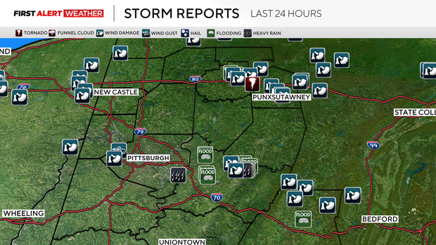
The main threat will be damaging wind gusts on the order of 60- 70 mph, along with heavy rainfall. The overall intensity of these storms should weaken by the time activity gets south of I-70 since areas south of I-70 have already seen plenty of rain today and are a bit more stable.
The thunderstorm threat should wind down by midnight as a cold front moves in from the northwest.
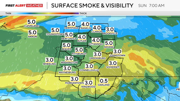
The northwest shift in wind direction will bring in another round of wildfire smoke. This smoke will move in after midnight and linger through the area on Sunday, creating a haze in the sky and near the surface.
The concentration of this smoke will not be near the levels we've seen the past couple of days, but there may be enough to reduce air quality to likely code orange levels for Sunday. Those who are sensitive to the smoke should still take precautions.
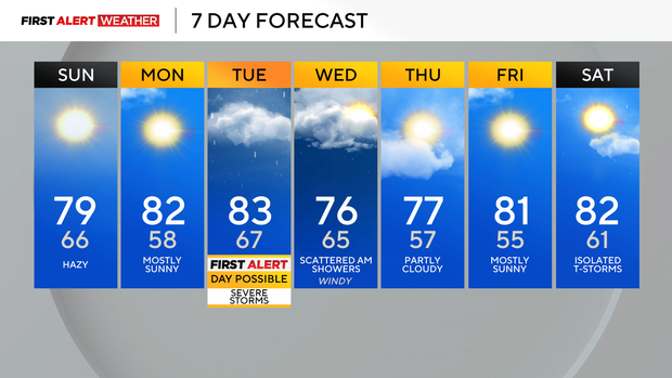
Sunday will be cooler with highs in the upper 70s to low 80s, and Sunday night into Monday morning will be pleasant with lows in the mid-50s to near 60 degrees.
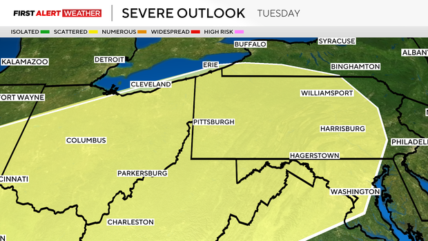
Dry conditions will be in place on Monday with some slight haze and wildfire smoke in the sky. As high pressure moves east, winds will shift to the southwest Monday night into Tuesday, bringing in moisture for our next storm system. There are timing differences among the models, with some showing rain and storms in the morning, which would lead to a lower severe weather potential.
Others break up the morning wave of storms and allow the atmosphere to become more unstable with a higher-end severe potential. This system will need to be watched closely as the wind energy and wind shear will be in place to support organized severe weather, but the timing of the system will ultimately determine how much of a threat we see.
A cold front passes through Tuesday evening into Wednesday with falling temperatures and a few showers. Temperatures will return to near and slightly below normal levels for the middle to end of next week.