Air quality alert in place for parts of the Pittsburgh area today

An air quality alert is in place today for parts of the Pittsburgh area.
Any alert days ahead? Nope. There are frost advisories in place for a couple of places this morning. Air quality alert in place for Allegheny County.
Aware: Patchy fog in place today. Conditions look to be more conducive to fog on Wednesday & Thursday mornings
Steelers in Paris: Dry for game day with game-time temperatures in the upper 50s. Rain chance for Saturday.
High pressure that responsible for our current seasonal weather pattern, anchored over the Great Lakes region will cause conditions favorable for low air quality. Air quality will likely be the worst for the hours starting at sunrise and continuing for the next two to three hours. Very fine particles, those of PM2.5 or smaller, are the biggest concern. This means surgical masks won't be much help for those who have respiratory issues. N95 respirators will filter out these fine particles that come from factory emissions.
While these emissions are always present, wind speeds and mixing in the atmosphere often help to filter these particles down to levels that aren't too harmful for us. High pressure causes sinking air, trapping these particles close to the surface. This, along with light wind speeds, means little mixing in the atmosphere to 'water down' the impact. The Mon Valley in southern Allegheny County is usually the area most impacted by poor air quality. Atmospheric conditions will continue to be conducive to poor air quality, especially during morning hours, through at least Thursday morning and probably through the weekend.
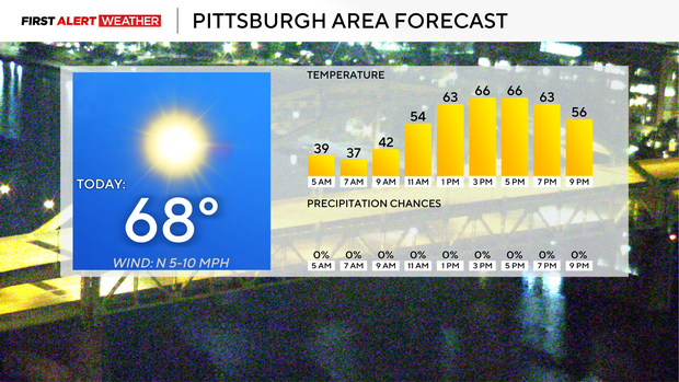
High pressure also means the stretch of pleasant weather will continue. Yesterday, high temperatures reached the mid to upper 60s across our area after a chilly start to the day. We should see highs back into the upper 60s today. I have Pittsburgh seeing a high of 67 degrees with sunny skies and light winds coming from the north. There will be some patchy fog around, especially north of I-80. Sunset is at 6:33 p.m.
Model data shows that fog chances both Wednesday and Thursday morning will be even more conducive to fog than this morning. We could see a fog advisory issued for those mornings. Morning lows, similar to this morning, should dip into the 30s most places. I have highs also remaining in the upper 60s. Dew points will tick up slightly, and this is the reason for the higher fog chance.
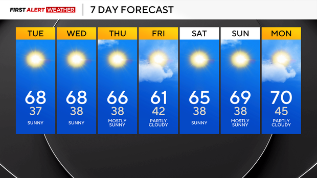
The weekend is looking pleasant with highs on Friday in the low 60s. Saturday highs should be in the mid-60s, with highs near 70 on Sunday and Monday.


