Wintry mix clears by midday Tuesday, tracking more snow and freezing rain around Philadelphia on Friday
The snow and rain that fell across the region earlier today will continue to move out, though the cloud cover will hang around as temperatures peak in the low 40s this afternoon in the Philadelphia region.
Any snow that did accumulate will continue to melt with temperatures remaining above freezing this afternoon and through the overnight. Low temperatures tonight will be relatively warm with lows in the mid-upper 30s.
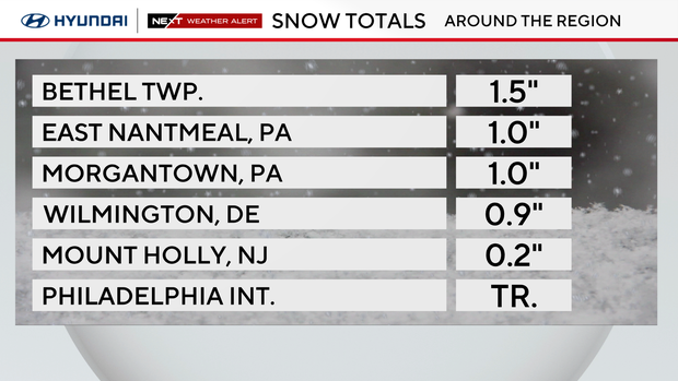
How much snow did the Philadelphia area get?
While Philadelphia only got a trace of snow Tuesday morning, areas farther north recorded closer to an inch of snow.
A Winter Weather Advisory is in effect for Lehigh and Northampton counties until 1 p.m. and for Carbon and Monroe counties until 4 p.m.
Conditions will improve through the afternoon as precipitation tapers off and temperatures climb into the 40s in and around the city.
Christmas Eve will feature plenty of sunshine with highs in the mid-upper 40s, but winds will increase through the day. By Wednesday afternoon gusts could reach 30 mph, which will make it feel more like the upper 30s through Wednesday afternoon.
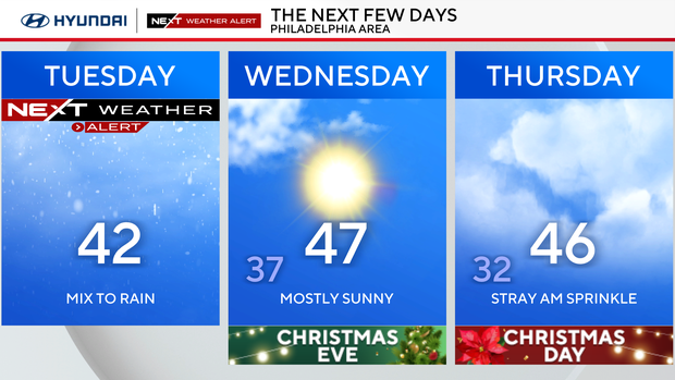
A fast-moving clipper system will bring a small chance for a couple light rain showers on Christmas morning, but the second half of Christmas should be dry with high temperatures in the middle 40s.
NEXT big weather change
Attention then turns to Friday, when a stronger system could impact the region. Current trends suggest a period of wintry precipitation is possible, especially north and west of I-95, with a gradual change to rain farther south.
Cold air ahead of a storm system tracking across the Midwest will set the stage for the chance of snow and even some freezing rain from late Friday afternoon through early Saturday morning.
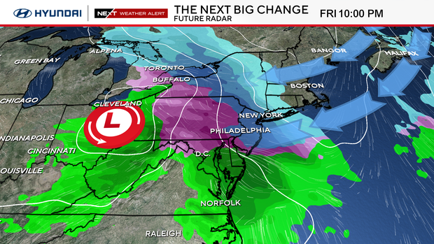
There remains some uncertainty in how the system will take shape, but it's looking more likely that our area receives some impacts as many people have travel plans to wrap up the Christmas week.
Here's your 7-day forecast:
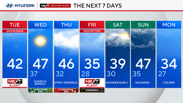
Tuesday: NEXT Weather Alert for mix to rain. High 42.
Wednesday/Christmas Eve: Sunny and breezy. High 47, low 37.
Thursday/Christmas Day: Chance of showers. High 46, low 32.
Friday: NEXT Weather Alert for wintry mix. High 35, low 28.
Saturday: Shower early. High 39, low 30.
Sunday: More showers. High 47, low 35.
Monday: Colder. High 34, low 27.


