Tracking rain, snow around Philadelphia area as temperatures plunge to 30s. Here's the weather forecast.
Rain showers are developing in the Philadelphia area Thursday, with even a chance of snow for some of us as temperatures plummet from their summer-like highs earlier this week.
Reality check: It's March and technically still winter in Philadelphia. March can be a volatile month, with huge temperature swings and everything from blizzards to tornadoes.
Temperatures will tank throughout Thursday, with afternoon temps only around 40 degrees. As precipitation becomes steadier Thursday afternoon and pulls in some of that cold air aloft, rain will eventually mix with or possibly change to snow in the afternoon for a time.
While ground temps are warm and we aren't expecting accumulation, heavy wet snow will limit visibility a bit and could even lead to slushy spots on grass, though mainly it would be classified as "White Rain." Rain and snow should clear the coast between 7 and 8 this evening.

NEXT big change
Now you'll need to prepare for one of the largest temperature drops in recent memory. This will be a real shock to the system as we plunge over 50 degrees in less than 36 hours.
Wednesday, we had a high of 83 degrees, and it dropped to the 60s by midnight. Then the temperature continues falling to the low 40s before noon Thursday and low 30s by the afternoon.
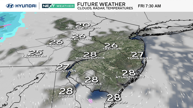
Finally, we'll bottom out in the mid-upper 20s by the time you wake up Friday morning.
This incredible temperature drop is courtesy of an extremely strong cold front that brought the additional threat of severe storms Wednesday evening, followed by cold rain Thursday morning and a rain/snow mix by the evening.
Seasonable conditions return with gusty winds into the weekend.
50-degree temperature swings are rare
Looking back at large temperature swings, we only need to turn to earlier this week. We saw a 43-degree diurnal change from 40 degrees Tuesday morning to the afternoon record high of 83.
It's not so bad when the swing is upward from a morning low, and it's common to have 30–40-degree warmups as warmer air arrives on southwest winds. It's much tougher when the temperature plummets by 50 degrees or more in 24-36 hours.
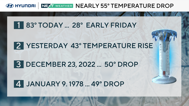
On Dec. 23, 2022, the high of 59 was in the very early morning, and the temperature fell to 9 degrees that night — a whopping 50-degree drop in 24 hours. Back in 1978, there was a 49-degree drop when the high of 61 on Jan. 9 fell to 12 degrees that night.
For these big temperature fluctuations to occur, we need to have a high temperature far above normal and a low temperature far below normal. That is exactly what we are looking at with the drop from the 80s Wednesday to the 20s in less than 36 hours.
As tempting as it may be to leave the house Thursday morning in short sleeves, please make sure to carry that winter coat and umbrella for your trip home Thursday night.
Here's your 7-day forecast:
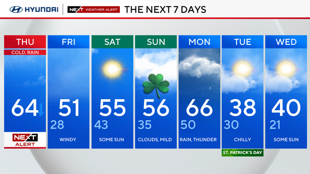
Thursday: NEXT Weather Alert as temps drop. High 64
Friday: Some sun. High 51, low 28.
Saturday: Partly sunny. High 55, low 43.
Sunday: Mild clouds. High 56, low 35.
Monday: Rain likely. High 66, low 50.
Tuesday/St. Patrick's Day: Chilly. High 38, low 30.
Wednesday: Partly cloudy. High 40, low 21.