Milder temps in Philadelphia Thursday, 10+ inches of snow possible during weekend storm
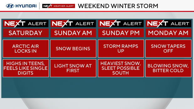
Two quiet and mild winter days are ahead as we prepare for what will likely be the biggest snowfall in a decade.
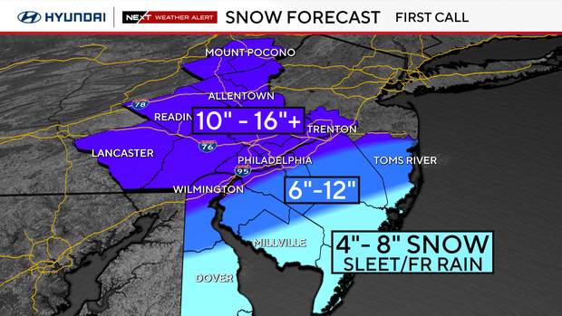
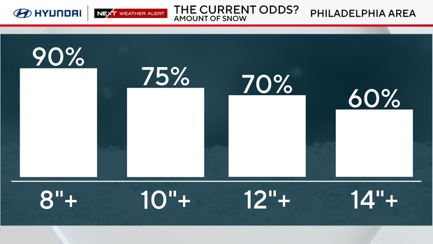
We currently have placed the probability of 8 inches or more of snow at 90% — the last time we had that much snow was 10 years ago tomorrow, when a storm dumped 22.4 inches in the city and over 30 inches northwest. While this storm is structured a bit differently, it is looking more and more likely that parts of our area will be in the bullseye zone of 12-16-plus inches. The exact track will determine that.
- The last time Philadelphia saw a 6-plus inches snowfall was 7.5 inches on Jan. 29, 2022
- The last time Philadelphia saw a 12-plus inches snowfall was 22.4 inches on Jan. 23, 2016
- The last time Philadelphia saw more than 24-plus inches of snow was 28.5 inches on Feb. 5 and 6, 2010
NEXT big weather change
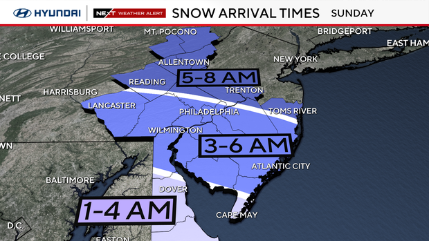
Snow will begin to overspread the area between midnight and 8 a.m. Sunday morning — it will likely be snowing at least lightly by the time most of the area wakes up and starts the day. Snow will fall at least moderately through midday, but will ramp up in intensity through the afternoon and into Sunday night as a coastal low develops offshore.
The snow will start out light and fluffy with cold air in place, but as the low deepens offshore, it will draw in warmer and moisture-rich air. This will lead to heavier snowfall rates with banding - rates may exceed 1-2" per hour - but will also mean a heavier, wetter snow and even the potential for some sleet or freezing rain, especially to the southeast.
The mixing threat is currently the biggest wild card because any sleet could cut snowfall totals, but where the precipitation stays all snow, it will pile up quickly. We have issued a first call snowfall map and will continue to refine exactly where the contours will set up, and determine where the most likely "bullseye" zone will be. Philadelphia right now is in a general 8-14 inches zone with 6-12 inches just to the southeast and 10-16 inches just northeast.
Impacts include power outages, airport cancellations, train delays, dangerous roads and downed trees.
School delays and closings are highly likely on Monday, Jan. 26.
Temperatures will plummet Monday through the middle of next week, with highs in the low 20s and overnight lows dipping to single digits and below zero. So, plan on this snow sticking around through the end of the month.
The best advice is to stay with the NEXT Weather team for frequent updates each day to plan and prepare for the weekend. Have the shovels and ice melt ready. This could be the biggest snow of the season.
Where to find warming centers around Philadelphia
Philadelphia has activated an Enhanced Code Blue due to the extremely cold temperatures. The city activates an "enhanced" alert when a Code Blue lasts more than three nights in a row.
Because of the enhanced alert, the Office of Emergency Management has opened multiple warming centers throughout the city. The centers are free and open to the public.
People who need help or see someone in need of help during this cold weather event can also call 215-232-1984.
Bucks County issues a Code Blue whenever temperatures drop below 20 degrees, but could also issue the alert based on other cold-weather factors.
Information about shelter openings can be found on the Housing Link website.
Residents who need temporary shelter, food and clothing during the winter can call 211 or text their zip code to 898-211 for immediate assistance.
During a Code Blue, residents in need of shelter are encouraged to visit one of Delaware County's weather advisory relief centers.
During a Code Blue, the county has additional resources for people experiencing homelessness, including access to temporary warming shelters, food and clothing.
Anyone who needs help with temporary shelter during the cold can call the Your Way Home Call Center at 610-278-3522.
New Jersey
Active Code Blue declarations are listed by county on New Jersey 211's website. The site also includes a list of available warming centers in each county.
Delaware
The Delaware Department of Health and Social Services has opened eight warming centers across the state through Jan. 21. A list of warming centers in each county and their addresses is posted online.
Here's your 7-day forecast:
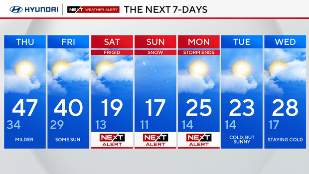
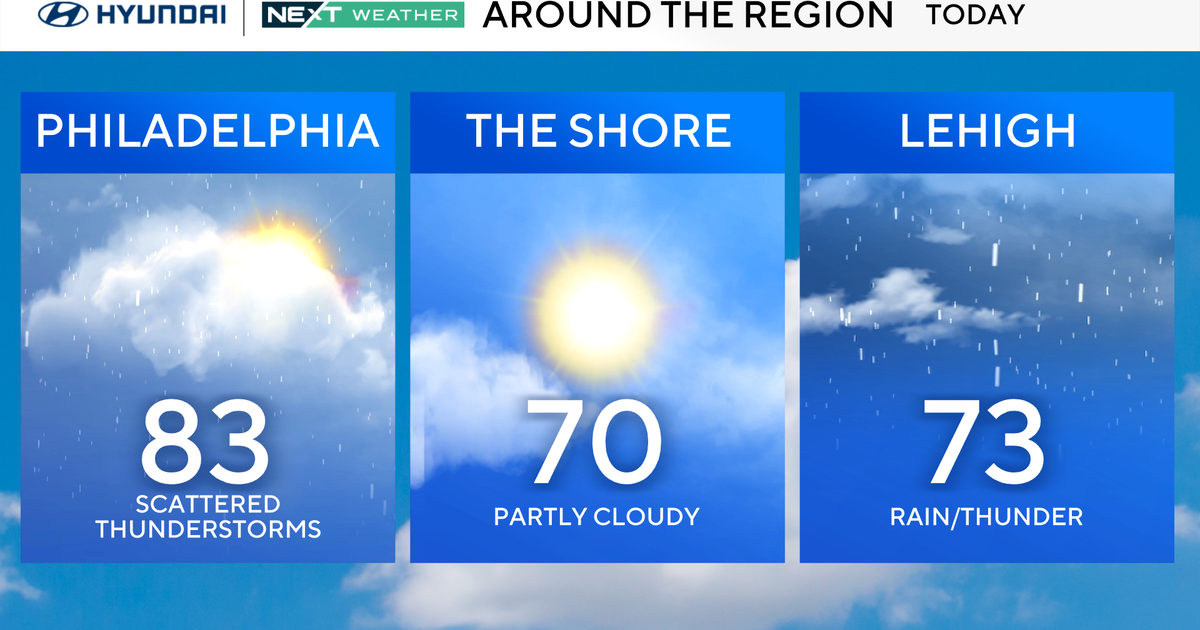
Thursday: Milder. High 47, Low 34
Friday: Some sun. High 40, Low 29
Saturday: NEXT Weather Alert frigid temps. High 19, Low 13
Sunday: NEXT Weather Alert for snow. High 17, Low 11
Monday: NEXT Weather Alert snowstorm aftermath. High 25, Low 14
Tuesday: Cold but sunny. High 23, Low 14
Wednesday: Staying cold. High 28, Low 17