Friday in Philadelphia region will be impacted by scattered storms, tropical humidity. Here's the forecast.
The entire Philadelphia region is under a severe thunderstorm watch as scattered strong thunderstorms will develop during the late afternoon on Friday.
In addition, we've issued a NEXT Weather Alert for the entire Philadelphia region.
Most of the day will be dry before storms first develop west of Philadelphia — then they begin tracking east through the city and suburbs during the evening commute.
Not everyone will see a storm, but the strongest cells will be capable of damaging wind gusts over 60 mph, torrential rainfall, frequent cloud-to-ground lightning, and isolated flash flooding.
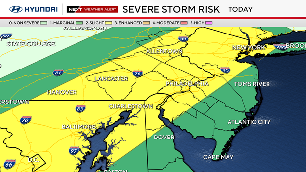
The Storm Prediction Center has placed a large portion of our region under a Level 2 or "slight" risk of severe weather. This area is centered around the I-95 corridor.
Keep a close eye on the radar if you have outdoor plans or travel later on Friday.
We're also under a heat advisory as tropical humidity makes temperatures feel like 100 degrees.
NEXT big weather changes
Once Friday's storms move out, the weather story quickly turns back to dangerous heat.
Temperatures surge into the lower 90s this weekend with tropical humidity pushing feels-like temperatures between 100 and 105 degrees.
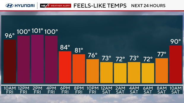
A Heat Advisory is in effect through Saturday, and additional evening thunderstorms are expected.
A slight reduction in the humidity Sunday and Monday should keep the storm threat at bay, but the heat continues with highs in the low to mid 90s.
Here's your 7-day forecast:
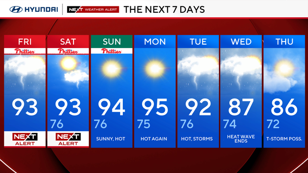
Friday: NEXT Weather Alert for heat and thunderstorms. High 93, Low 77.
Saturday: NEXT Weather Alert for heat and thunderstorms. High 93, Low 76.
Sunday: Sunny, hot. High 94, Low 76.
Monday: Mostly sunny. High 95, Low 75.
Tuesday: Evening thunderstorm. High 92, Low 76.
Wednesday: Chance of showers. High 87, Low 74.
Thursday: Chance of showers. High 86, Low 72.


